New York · Monthly
September 2026
Downloads
1 Key messages and climate synopsis
Source: NOAA NCEI
Source: NOAA NCEI
2 Global and regional climate drivers
Sea-surface temperature anomaly, September 2026 (°C, 1991–2020)
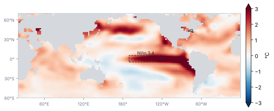
Source: NOAA NCEI / PSL
Sea-surface temperature anomaly in the Niño regions (°C)
| Region | Anomaly (°C) | Change from preceding period (°C) |
|---|---|---|
| Niño 1+2 | 4.7 | 0.6 |
| Niño 3 | 3.6 | 0.5 |
| Niño 3.4 | 2.8 | 0.3 |
| Niño 4 | 0.9 | 0.0 |
Mean of the months in the period (OISST v2.1)
Source: NOAA CPC
El Niño conditions of very strong intensity: the Oceanic Niño Index (ONI) for JAS 2026 was +2.2 °C.
Source: NOAA CPC
Monthly Niño 3.4 anomaly, last 24 months (°C)
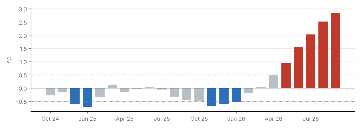
Source: NOAA CPC
MJO phase diagram (real-time OMI)
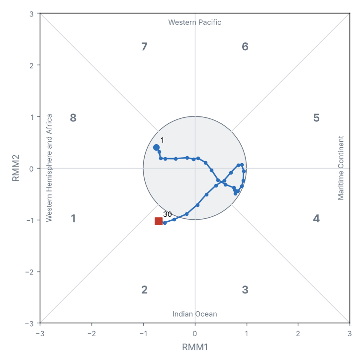
Source: NOAA PSL
Teleconnection indices
| Index | Value | Phase |
|---|---|---|
| NAO | 0.5 | Positive |
| AO | 1.2 | Positive |
| PDO | −1.6 | Negative |
North Atlantic Oscillation (NAO); Arctic Oscillation (AO); Pacific Decadal Oscillation (PDO).
Source: NOAA CPC, NOAA NCEI
The Niño 3.4 anomaly was +2.84 °C (+0.32 °C relative to the preceding period).
The MJO was active on 3 of 30 days, most often in phase 2 (Indian Ocean); mean amplitude 0.7.
Other indices: NAO +0.53 (positive phase); AO +1.16 (positive phase); PDO −1.55 (negative phase).
3 Precipitation
Source: NOAA NCEI
Accumulated precipitation
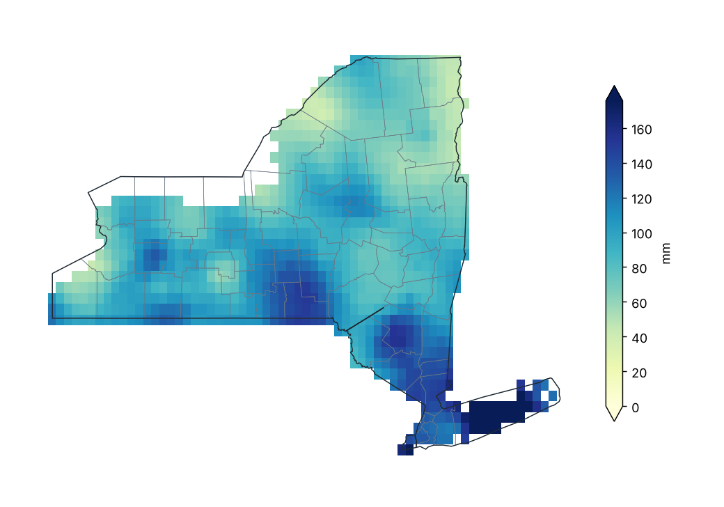
Source: NOAA NCEI
Percent of normal precipitation (1991–2020)
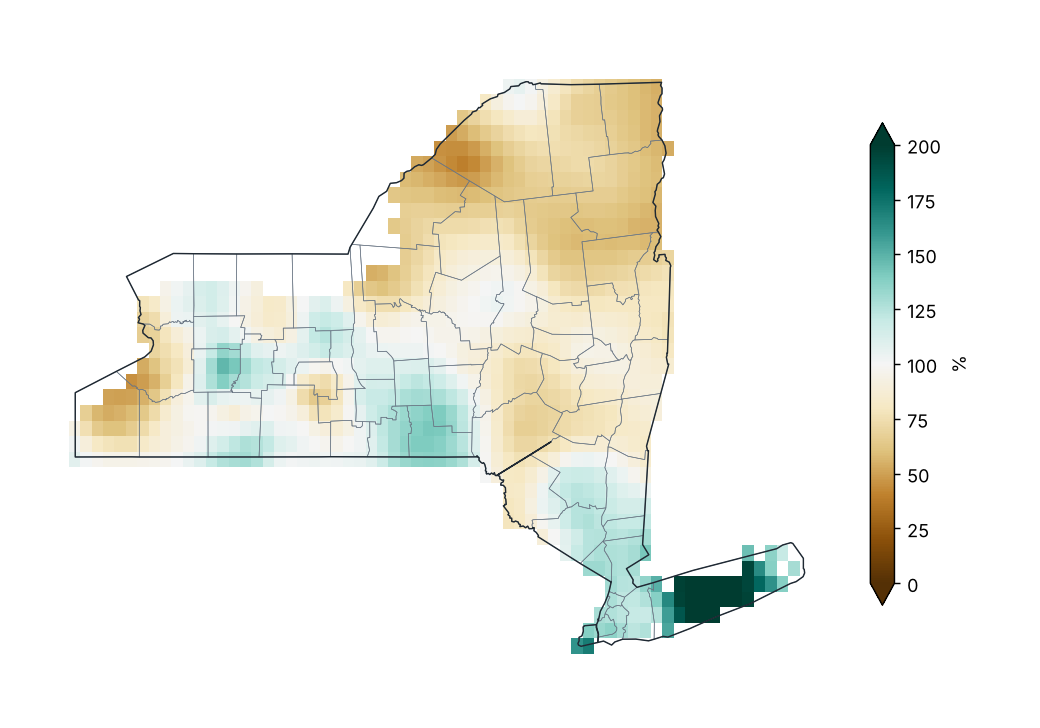
Source: NOAA NCEI
Percent of normal by county
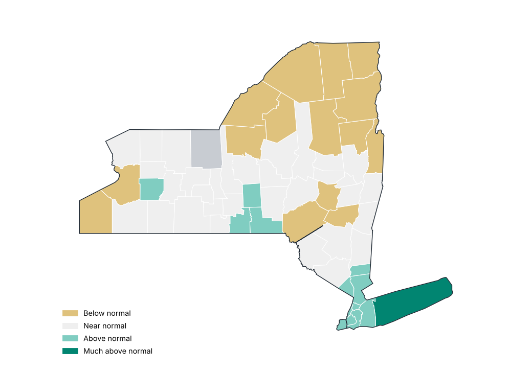
Source: NOAA NCEI
Precipitation by region
| Region | Total (mm) | Normal (mm) | Difference (%) | Category |
|---|---|---|---|---|
| Western Plateau | 98.3 | 100.0 | −1.7 | Near normal |
| Eastern Plateau | 107.9 | 110.5 | −2.4 | Near normal |
| Northern Plateau | 77.9 | 103.6 | −24.8 | Below normal |
| Coastal | 164.4 | 99.6 | 65.1 | Much above normal |
| Hudson Valley | 105.2 | 106.2 | −1.0 | Near normal |
| Mohawk Valley | 92.4 | 100.8 | −8.3 | Near normal |
| Champlain Valley | 56.9 | 91.9 | −38.1 | Below normal |
| St. Lawrence Valley | 70.2 | 101.6 | −30.8 | Below normal |
| Great Lakes | 76.5 | 95.9 | −20.3 | Below normal |
| Central Lakes | 98.1 | 93.0 | 5.5 | Near normal |
Source: NOAA NCEI
Stations with the largest precipitation excess
| Region | County | Station | Altitude (m) | Anomaly (%) |
|---|---|---|---|---|
| Coastal | Suffolk | Islip-Li Macarthur AP | 25.0 | 143.1 |
| Coastal | Suffolk | Westhampton Gabreski AP | 13.0 | 142.9 |
| Coastal | Suffolk | Riverhead Rsch Farm | 30.0 | 129.3 |
| Coastal | Suffolk | Upton Coop - Nwsfo New York | 24.0 | 122.0 |
| Central Lakes | Wyoming | Warsaw 6 SW | 555.0 | 79.5 |
| Western Plateau | Allegany | Wellsville | 460.0 | 67.1 |
| Eastern Plateau | Chenango | Greene | 280.0 | 64.3 |
| Great Lakes | Wayne | Newark | 131.0 | 64.0 |
| Central Lakes | Livingston | Hemlock | 275.0 | 60.7 |
| Central Lakes | Livingston | Mt Morris 2W | 268.0 | 58.9 |
Source: NOAA NCEI
Stations with the largest precipitation deficit
| Region | County | Station | Altitude (m) | Anomaly (%) |
|---|---|---|---|---|
| St. Lawrence Valley | St. Lawrence | Gouverneur 3 NW | 128.0 | −72.1 |
| Great Lakes | Oswego | Oswego | 99.0 | −57.9 |
| Champlain Valley | Essex | Elizabethtown | 186.0 | −53.0 |
| Great Lakes | Chautauqua | Dunkirk Chautauqua Co AP | 204.0 | −52.7 |
| Great Lakes | Niagara | N Tonawanda | 176.0 | −51.3 |
| Northern Plateau | Hamilton | Indian Lake 2SW | 509.0 | −46.8 |
| Great Lakes | Oswego | Fulton Oswego Co AP | 144.0 | −46.3 |
| Western Plateau | Allegany | Angelica | 450.0 | −44.3 |
| Central Lakes | Yates | Penn Yan AP | 267.0 | −43.6 |
| Great Lakes | Niagara | Niagara Falls | 179.0 | −41.5 |
Source: NOAA NCEI
Largest 24-hour rainfall at stations
| Station | County | Max 24 h rainfall (mm) | Date |
|---|---|---|---|
| Massena Intl AP | St. Lawrence | 80.5 | 2026-09-02 |
| Pavilion 2 | Genesee | 80.0 | 2026-09-04 |
| Islip-Li Macarthur AP | Suffolk | 77.7 | 2026-09-13 |
| Buffalo | Erie | 77.2 | 2026-09-03 |
| Medina | Orleans | 76.7 | 2026-09-03 |
| Greene | Chenango | 68.3 | 2026-09-03 |
| Riverhead Rsch Farm | Suffolk | 64.0 | 2026-09-13 |
| Baiting Hollow | Suffolk | 58.4 | 2026-09-28 |
| Trenton Falls | Herkimer | 57.7 | 2026-09-10 |
| Warsaw 6 SW | Wyoming | 57.2 | 2026-09-04 |
Source: NOAA NCEI
Daily statewide mean precipitation
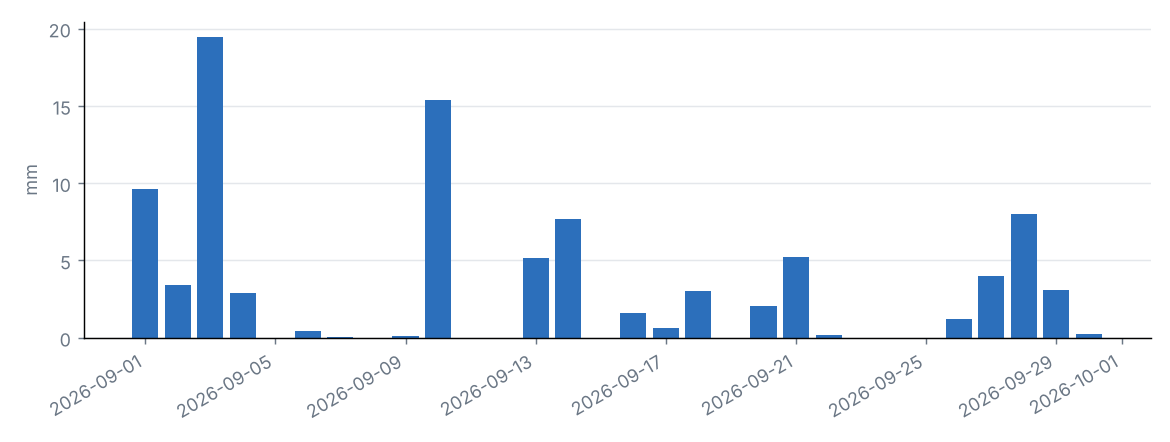
Source: NOAA NCEI
Daily statewide mean and grid-cell maximum
| Day | Statewide mean (mm) | Grid maximum (mm) | County |
|---|---|---|---|
| 2026-09-01 | 9.6 | 21.7 | Lewis |
| 2026-09-02 | 3.4 | 14.6 | Suffolk |
| 2026-09-03 | 19.5 | 57.5 | Wyoming |
| 2026-09-04 | 2.9 | 15.2 | Chautauqua |
| 2026-09-05 | 0.0 | 1.1 | Chautauqua |
| 2026-09-06 | 0.5 | 3.4 | Essex |
| 2026-09-07 | 0.0 | 1.5 | Rensselaer |
| 2026-09-08 | 0.0 | 0.1 | Ontario |
| 2026-09-09 | 0.1 | 2.1 | St. Lawrence |
| 2026-09-10 | 15.4 | 36.1 | Oneida |
| 2026-09-11 | 0.0 | 1.0 | Columbia |
| 2026-09-12 | 0.0 | 0.3 | Oswego |
| 2026-09-13 | 5.1 | 18.3 | Allegany |
| 2026-09-14 | 7.7 | 38.3 | Suffolk |
| 2026-09-15 | 0.0 | 0.1 | Ontario |
| 2026-09-16 | 1.6 | 9.1 | Chautauqua |
| 2026-09-17 | 0.7 | 9.4 | Chautauqua |
| 2026-09-18 | 3.0 | 10.4 | Chenango |
| 2026-09-19 | 0.0 | 0.1 | Chemung |
| 2026-09-20 | 2.1 | 8.7 | Chenango |
| 2026-09-21 | 5.2 | 18.9 | Ulster |
| 2026-09-22 | 0.2 | 5.5 | Chautauqua |
| 2026-09-23 | 0.0 | 0.8 | Richmond |
| 2026-09-24 | 0.0 | 0.0 | St. Lawrence |
| 2026-09-25 | 0.0 | 0.2 | Schoharie |
| 2026-09-26 | 1.2 | 24.8 | Suffolk |
| 2026-09-27 | 4.0 | 49.0 | Suffolk |
| 2026-09-28 | 8.0 | 48.6 | Suffolk |
| 2026-09-29 | 3.1 | 17.1 | Dutchess |
| 2026-09-30 | 0.2 | 1.5 | Essex |
Source: NOAA NCEI
Statewide precipitation in September of each year
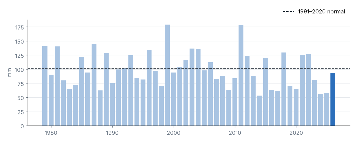
Source: NOAA NCEI
Statewide accumulated precipitation was 93.4 mm, 92% of the 1991–2020 average (101.5 mm), category “Near normal”. It was the 23rd driest September in the 1979–2026 series.
The region with the highest percentage of normal was Coastal (165%) and the lowest was Champlain Valley (62%).
The largest daily grid-cell total was estimated on 3 September in Wyoming (57.5 mm).
Source: NOAA NCEI
4 Temperature
Source: NOAA NCEI
Mean temperature
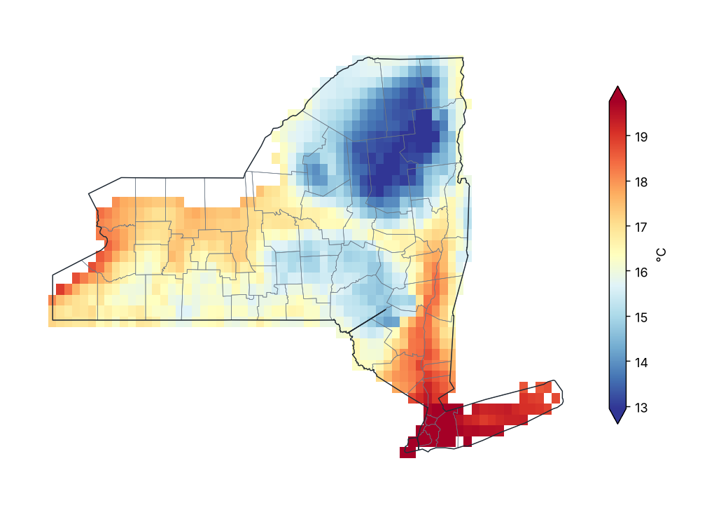
Source: NOAA NCEI
Mean temperature anomaly (1991–2020)
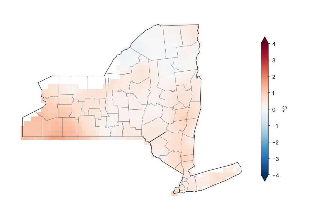
Source: NOAA NCEI
Mean temperature anomaly by region
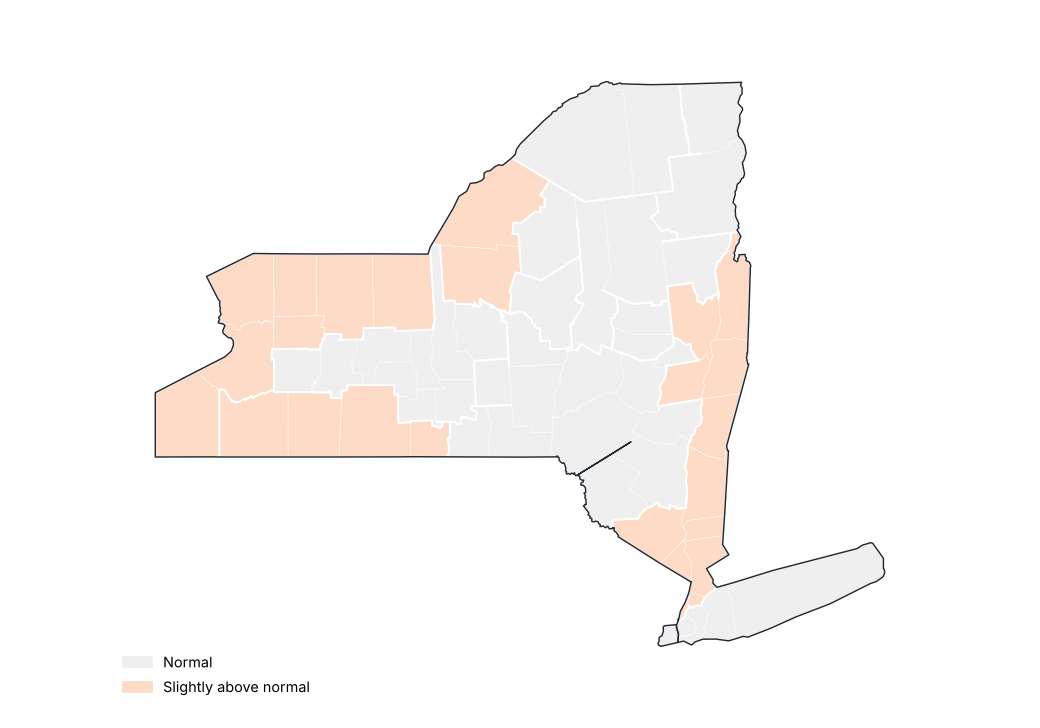
Source: NOAA NCEI
Stations with the largest positive anomaly
| Region | County | Station | Altitude (m) | Anomaly (°C) |
|---|---|---|---|---|
| Western Plateau | Cattaraugus | Little Valley | 495.0 | 1.2 |
| Central Lakes | Wyoming | Warsaw 6 SW | 555.0 | 1.1 |
| Western Plateau | Cattaraugus | Allegany Sp | 457.0 | 1.0 |
| Great Lakes | Niagara | N Tonawanda | 176.0 | 1.0 |
| Great Lakes | Erie | Wales | 343.0 | 0.9 |
| Western Plateau | Allegany | Angelica | 450.0 | 0.9 |
| Great Lakes | Oswego | Oswego | 99.0 | 0.8 |
| Western Plateau | Cattaraugus | Franklinville | 485.0 | 0.8 |
| Coastal | Suffolk | Westhampton Gabreski AP | 13.0 | 0.7 |
| St. Lawrence Valley | St. Lawrence | Gouverneur 3 NW | 128.0 | 0.7 |
Source: NOAA NCEI
Stations with the largest negative anomaly
| Region | County | Station | Altitude (m) | Anomaly (°C) |
|---|---|---|---|---|
| Hudson Valley | Orange | Port Jervis | 177.0 | −1.4 |
| St. Lawrence Valley | Franklin | Saranac Lk Adirondack Rgnl AP | 506.0 | −0.8 |
| Western Plateau | Chemung | Elmira | 289.0 | −0.8 |
| Northern Plateau | Hamilton | Indian Lake 2SW | 509.0 | −0.7 |
| Champlain Valley | Essex | Lake Placid 2 S | 576.0 | −0.6 |
| Eastern Plateau | Chenango | Norwich | 301.0 | −0.5 |
| Great Lakes | Jefferson | Watertown AP | 95.0 | −0.4 |
| Hudson Valley | New York | Ny City Cntrl Park | 43.0 | −0.4 |
| Central Lakes | Tompkins | Ithaca Cornell Univ | 293.0 | −0.3 |
| Central Lakes | Cayuga | Auburn | 235.0 | −0.3 |
Source: NOAA NCEI
Statewide mean temperature anomaly in September of each year
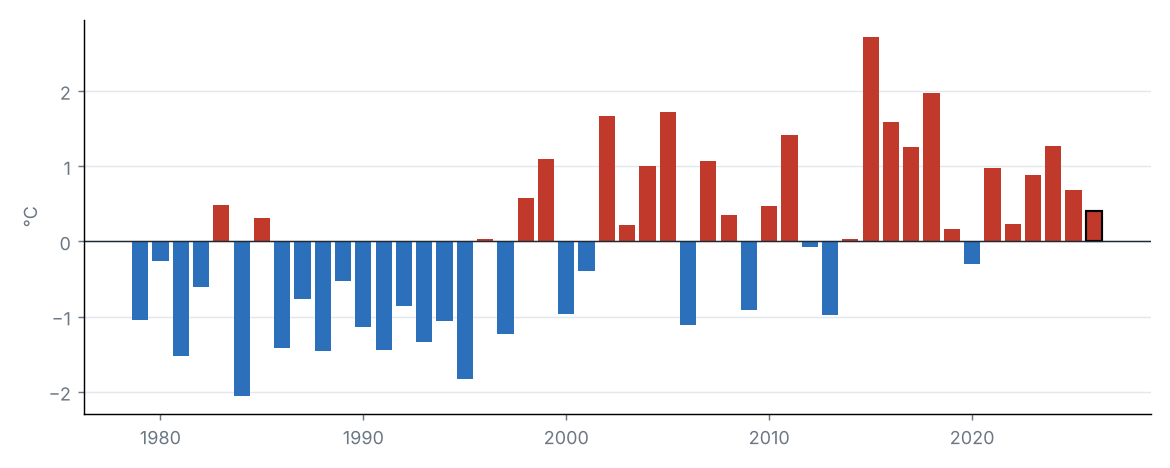
Source: NOAA NCEI
The statewide mean temperature was 16.1 °C, 0.4 °C above the 1991–2020 average (15.7 °C), category “Normal”. It was the 18th warmest September in the 1979–2026 series (tied with 2008).
By region, the largest anomaly was in Western Plateau (+0.9 °C) and the smallest in St. Lawrence Valley (+0.0 °C).
Source: NOAA NCEI
Source: NOAA NCEI
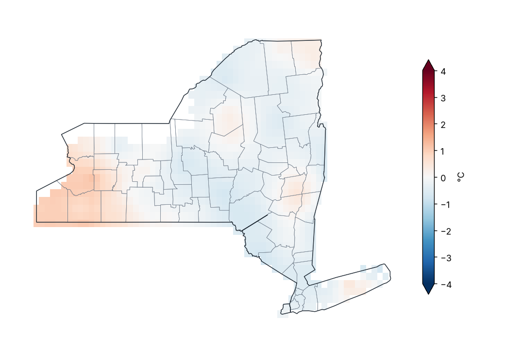
Maximum temperature anomaly (1991–2020)
Source: NOAA NCEI
Lowest and highest monthly mean maximum temperature by region
| Region | Lowest value (°C) | Station | Highest value (°C) | Station |
|---|---|---|---|---|
| Western Plateau | 20.8 | Wellsville Muni AP | 23.0 | Elmira |
| Eastern Plateau | 19.9 | Cooperstown | 22.2 | Whitney Pt Dam |
| Northern Plateau | 18.4 | Indian Lake 2SW | 21.4 | Lowville |
| Coastal | 21.9 | Montauk AP | 24.4 | Laguardia AP |
| Hudson Valley | 20.6 | Conklingville Dam | 23.6 | Poughkeepsie AP |
| Mohawk Valley | 18.5 | Gloversville 7NW (Peck Lake) | 22.4 | Rome Griffiss Airfield |
| Champlain Valley | 18.0 | Lake Placid 2 S | 21.2 | Plattsburgh Intl AP |
| St. Lawrence Valley | 19.1 | Saranac Lk Adirondack Rgnl AP | 21.2 | Massena Intl AP |
| Great Lakes | 21.6 | Watertown AP | 24.1 | Dunkirk |
| Central Lakes | 19.8 | Wyoming 3W | 23.5 | Dansville Muni AP |
Station monthly means (GHCN-Daily, ≥ 80% of days with data).
Source: NOAA NCEI
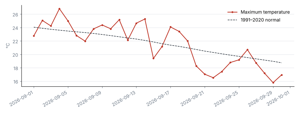
Daily statewide maximum temperature
Source: NOAA NCEI
The statewide maximum temperature was 21.5 °C, 0.1 °C below the 1991–2020 average (21.6 °C), category “Normal”. It was the 22nd coldest September in the 1979–2026 series (tied with 2003, 2020).
By region, the largest anomaly was in Western Plateau (+0.4 °C) and the smallest in Eastern Plateau (−0.4 °C).
Source: NOAA NCEI
Source: NOAA NCEI
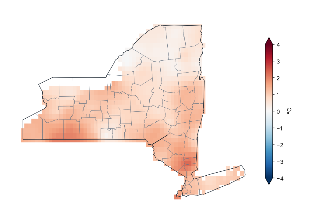
Minimum temperature anomaly (1991–2020)
Source: NOAA NCEI
Lowest and highest monthly mean minimum temperature by region
| Region | Lowest value (°C) | Station | Highest value (°C) | Station |
|---|---|---|---|---|
| Western Plateau | 8.6 | Elmira | 11.3 | Wellsville Muni AP |
| Eastern Plateau | 9.5 | Norwich | 12.0 | Binghamton |
| Northern Plateau | 7.2 | Indian Lake 2SW | 9.7 | Glens Falls AP |
| Coastal | 14.1 | Upton Coop - Nwsfo New York | 18.2 | Laguardia AP |
| Hudson Valley | 10.8 | Buskirk | 16.9 | Ny City Cntrl Park |
| Mohawk Valley | 9.1 | Boonville 4 SSW | 12.1 | Rome Griffiss Airfield |
| Champlain Valley | 7.8 | Newcomb | 11.3 | Plattsburgh Intl AP |
| St. Lawrence Valley | 5.2 | Saranac Lk Adirondack Rgnl AP | 10.9 | Gouverneur 3 NW |
| Great Lakes | 9.0 | Watertown AP | 14.6 | Oswego |
| Central Lakes | 9.9 | Ithaca Cornell Univ | 12.9 | Freeville 1 NE |
Station monthly means (GHCN-Daily, ≥ 80% of days with data).
Source: NOAA NCEI
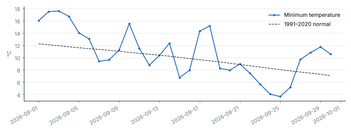
Daily statewide minimum temperature
Source: NOAA NCEI
The statewide minimum temperature was 10.7 °C, 0.9 °C above the 1991–2020 average (9.8 °C), category “Slightly above normal”. It was the 13th warmest September in the 1979–2026 series (tied with 1996, 2010, 2016).
By region, the largest anomaly was in Western Plateau (+1.4 °C) and the smallest in St. Lawrence Valley (+0.3 °C).
Source: NOAA NCEI
5 Climate extremes and records
Source: NOAA NCEI
Highest maximum temperature by county
| County | Station | Temperature (°C) | Date |
|---|---|---|---|
| Chautauqua | Dunkirk | 32.2 | 2026-09-03 |
| Queens | Laguardia AP | 31.1 | 2026-09-03 |
| Suffolk | Farmingdale Republic AP | 31.1 | 2026-09-03 |
| Allegany | Alfred | 30.6 | 2026-09-02 |
| Dutchess | Poughkeepsie AP | 30.6 | 2026-09-10 |
| Livingston | Dansville Muni AP | 30.6 | 2026-09-02 |
| Monroe | Brockport | 30.6 | 2026-09-02 |
| Cattaraugus | Little Valley | 30.0 | 2026-09-02 |
| Chemung | Elmira Corning Rgnl AP | 30.0 | 2026-09-01 |
| Westchester | Shrub Oak | 30.0 | 2026-09-11 |
| Niagara | N Tonawanda | 29.4 | 2026-09-03 |
| Onondaga | Syracuse Hancock Intl AP | 29.4 | 2026-09-02 |
| Ontario | Canandaigua 3 S | 29.4 | 2026-09-03 |
| Orange | Montgomery Orange Co AP | 29.4 | 2026-09-10 |
| Erie | Colden 1W | 28.9 | 2026-09-03 |
| Genesee | Batavia | 28.9 | 2026-09-03 |
| New York | Ny City Cntrl Park | 28.9 | 2026-09-03 |
| Orleans | Albion | 28.9 | 2026-09-02 |
| Oswego | Oswego | 28.9 | 2026-09-02 |
| Yates | Penn Yan AP | 28.9 | 2026-09-02 |
The 20 most extreme of 47.
Source: NOAA NCEI
Lowest minimum temperature by county
| County | Station | Temperature (°C) | Date |
|---|---|---|---|
| Franklin | Saranac Lk Adirondack Rgnl AP | −3.3 | 2026-09-24 |
| Chemung | Elmira | −0.6 | 2026-09-11 |
| Hamilton | Indian Lake 2SW | −0.6 | 2026-09-25 |
| Cattaraugus | Franklinville | 0.0 | 2026-09-25 |
| Delaware | Delhi 2 SE | 0.0 | 2026-09-25 |
| Lewis | Highmarket 2W | 0.0 | 2026-09-25 |
| Allegany | Angelica | 0.6 | 2026-09-25 |
| Chenango | Sherburne | 0.6 | 2026-09-26 |
| Essex | Newcomb | 0.6 | 2026-09-20 |
| Tompkins | Ithaca Cornell Univ | 0.6 | 2026-09-24 |
| Cortland | Ithaca 13 E | 0.9 | 2026-09-24 |
| Dutchess | Millbrook 3 W | 0.9 | 2026-09-24 |
| St. Lawrence | Massena Intl AP | 1.1 | 2026-09-24 |
| Warren | Glens Falls AP | 1.1 | 2026-09-24 |
| Chautauqua | Jamestown 4 ENE | 1.7 | 2026-09-25 |
| Jefferson | Watertown AP | 1.7 | 2026-09-24 |
| Rensselaer | Buskirk | 1.7 | 2026-09-24 |
| Schoharie | Lansing Manor | 1.7 | 2026-09-24 |
| Steuben | Hornell Almond Dam | 1.7 | 2026-09-26 |
| Clinton | Plattsburgh Intl AP | 2.2 | 2026-09-24 |
The 20 most extreme of 48.
Source: NOAA NCEI
Climate-extremes indices (statewide mean)
| Index | Description | Value | Normal | Difference | Unit |
|---|---|---|---|---|---|
| TX90p | Warm days (Tmax > 90th percentile) | 1.9 | 10.0 | −8.1 | % |
| TN90p | Warm nights (Tmin > 90th percentile) | 10.5 | 10.0 | 0.5 | % |
| TX10p | Cool days (Tmax < 10th percentile) | 1.6 | 10.0 | −8.4 | % |
| TN10p | Cold nights (Tmin < 10th percentile) | 1.2 | 10.0 | −8.8 | % |
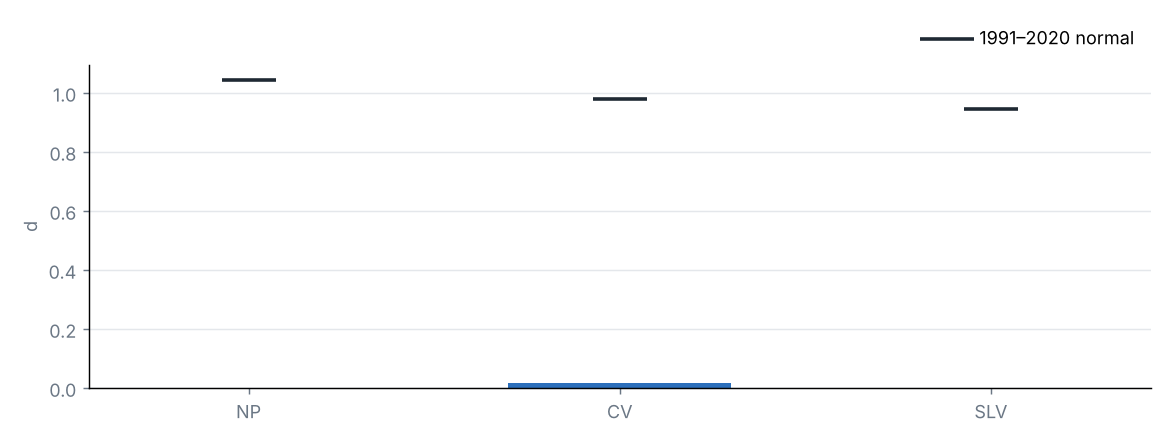
| FD | Frost days (Tmin < 0 °C) | 0.0 | 0.4 | −0.4 | d |
| SU | Summer days (Tmax > 25 °C) | 5.6 | 7.4 | −1.8 | d |
| TR | Tropical nights (Tmin > 20 °C) | 0.3 | 0.3 | 0.0 | d |
| WSDI | Warm spell days (≥ 6 days) | 0.0 | — | — | d |
| CSDI | Cold spell days (≥ 6 days) | 0.0 | — | — | d |
| Rx1day | Maximum 1-day precipitation | 26.4 | 32.2 | −5.9 | mm |
| Rx5day | Maximum 5-day precipitation | 43.6 | 49.8 | −6.2 | mm |
| CDD | Consecutive dry days (< 1 mm) | 6.4 | 7.8 | −1.4 | d |
| CWD | Consecutive wet days (≥ 1 mm) | 3.3 | 3.6 | −0.3 | d |
Percentile indices relative to calendar-day percentiles of 1991–2020 (5-day window); counts and maxima averaged over the state's grid cells.
Source: NOAA NCEI
Frost days by region
Source: NOAA NCEI
6 Drought
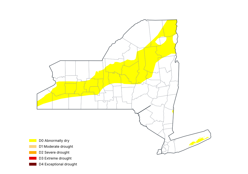
U.S. Drought Monitor, 29 September 2026
Source: National Drought Mitigation Center, USDA, NOAA
Share of the state by drought category, weekly U.S. Drought Monitor maps (%)
| Map of | None (%) | D0–D4 (%) | D1–D4 (%) | D2–D4 (%) | D3–D4 (%) | D4 (%) |
|---|---|---|---|---|---|---|
| 2026-09-01 | 76.6 | 23.4 | 0.1 | 0.0 | 0.0 | 0.0 |
| 2026-09-08 | 77.7 | 22.3 | 0.1 | 0.0 | 0.0 | 0.0 |
| 2026-09-15 | 81.2 | 18.8 | 0.1 | 0.0 | 0.0 | 0.0 |
| 2026-09-22 | 82.0 | 18.0 | 0.0 | 0.0 | 0.0 | 0.0 |
| 2026-09-29 | 67.6 | 32.4 | 0.0 | 0.0 | 0.0 | 0.0 |
Cumulative shares: D1–D4 is the share in moderate drought or worse.
Source: National Drought Mitigation Center, USDA, NOAA
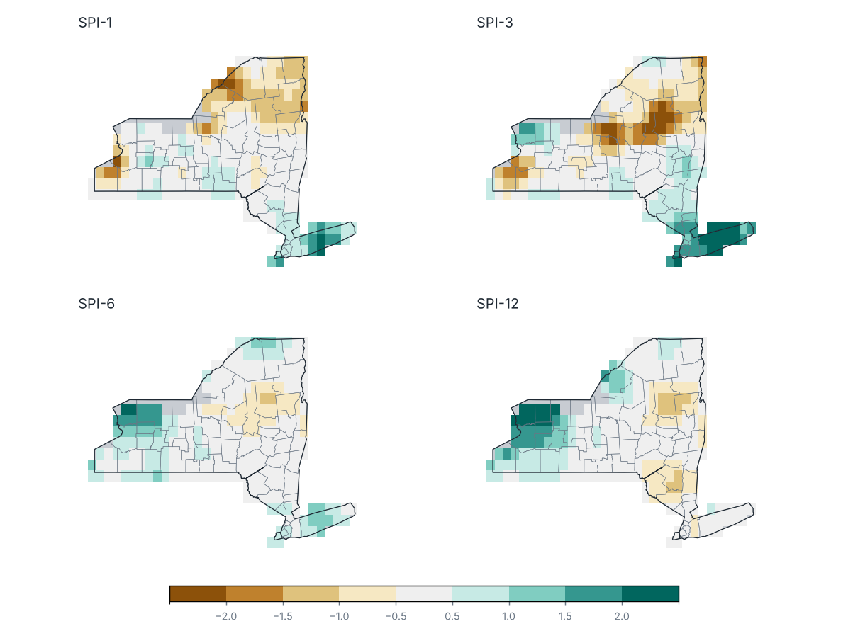
Standardized Precipitation Index (SPI) ending September 2026
Source: NOAA NCEI
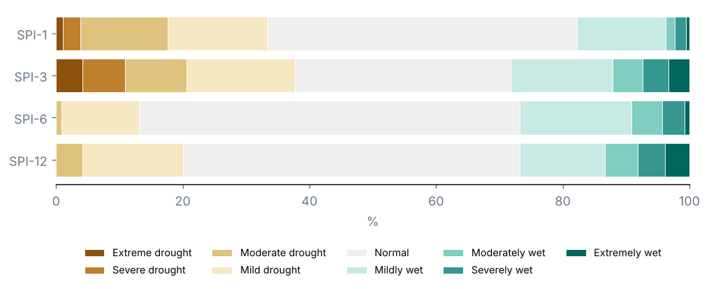
Share of the state by SPI category
Source: NOAA NCEI
Counties with the lowest SPI-3
| County | SPI-1 | SPI-3 | SPI-6 | SPI-12 | Category |
|---|---|---|---|---|---|
| Hamilton | −1.0 | −2.1 | −0.9 | −1.0 | Extreme drought |
| Oswego | −1.0 | −1.7 | −0.4 | 0.3 | Severe drought |
| Herkimer | −0.4 | −1.5 | −0.7 | −0.4 | Severe drought |
| Oneida | −0.1 | −1.5 | −0.6 | −0.1 | Moderate drought |
| Onondaga | −0.1 | −1.4 | −0.1 | 0.3 | Moderate drought |
| Chautauqua | −0.9 | −1.1 | 0.4 | 1.1 | Moderate drought |
| Warren | −1.0 | −1.0 | −0.7 | −0.9 | Moderate drought |
| Essex | −1.2 | −1.0 | −0.2 | −0.3 | Moderate drought |
| Clinton | −1.1 | −0.9 | 0.3 | 0.0 | Mild drought |
| Yates | −0.2 | −0.8 | 0.2 | 0.2 | Mild drought |
Source: NOAA NCEI
U.S. Drought Monitor, map of 29 September 2026: 0% of the state in drought (D1–D4), 0% in severe drought or worse (D2–D4) and 0% in extreme or exceptional drought (D3–D4); 32% was abnormally dry or in drought (D0–D4).
On the map of 25 August 2026, 0% of the state was in drought: a change of −0 points over the period.
No part of the state was in drought (D1–D4).
SPI-3 (Jul–Sep 2026): statewide mean −0.12; 21% of the state in drought (SPI ≤ −1.0) and 11% in severe or extreme drought.
Most affected counties: Hamilton (−2.06), Oswego (−1.71) and Herkimer (−1.52).
SPI-1 (September 2026): 18% of the state in drought.
SPI-6 (Apr–Sep 2026): 1% of the state in drought.
SPI-12 (Oct 2025–Sep 2026): 4% of the state in drought.
7 Severe weather and notable events
No tropical cyclone came within 300 km of the state.
9 Outlook
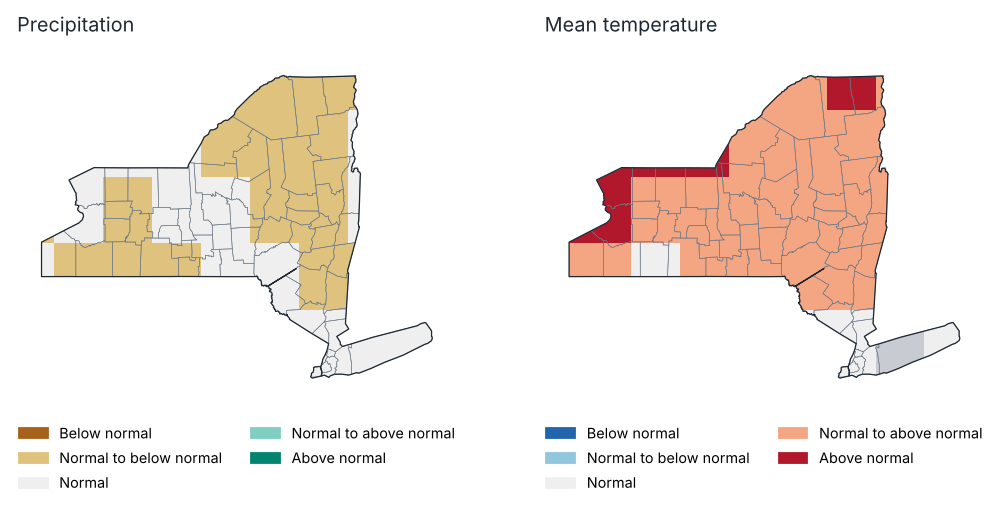
Outlook for October 2026: most likely tercile
Source: NOAA CPC
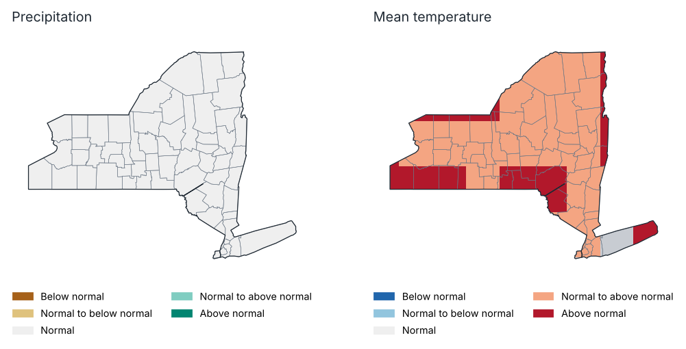
Outlook for Oct–Dec 2026: most likely tercile
Source: NOAA CPC
Probability of each tercile by region, Oct–Dec 2026 (%)
| Region | Precipitation: below | Precipitation: normal | Precipitation: above | Temp.: below | Temp.: normal | Temp.: above |
|---|---|---|---|---|---|---|
| Western Plateau | 34.0 | 31.0 | 35.0 | 16.0 | 34.0 | 51.0 |
| Eastern Plateau | 33.0 | 33.0 | 35.0 | 23.0 | 29.0 | 49.0 |
| Northern Plateau | 32.0 | 34.0 | 34.0 | 24.0 | 29.0 | 47.0 |
| Coastal | 33.0 | 33.0 | 34.0 | 22.0 | 27.0 | 51.0 |
| Hudson Valley | 33.0 | 32.0 | 34.0 | 22.0 | 29.0 | 49.0 |
| Mohawk Valley | 33.0 | 33.0 | 34.0 | 25.0 | 29.0 | 46.0 |
| Champlain Valley | 32.0 | 33.0 | 34.0 | 22.0 | 28.0 | 50.0 |
| St. Lawrence Valley | 32.0 | 33.0 | 34.0 | 23.0 | 28.0 | 48.0 |
| Great Lakes | 34.0 | 33.0 | 34.0 | 20.0 | 30.0 | 49.0 |
| Central Lakes | 33.0 | 33.0 | 34.0 | 22.0 | 30.0 | 48.0 |
Source: NOAA CPC
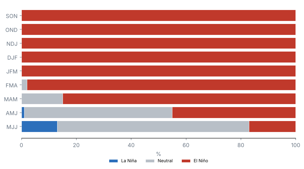
ENSO outlook: probability of each phase (%)
Source: NOAA CPC
Probabilistic outlook from the North American Multi-Model Ensemble (NMME), initialised in October 2026, relative to 1991–2020 terciles. It is not an official forecast: consult the National Weather Service and NOAA's Climate Prediction Center.
Precipitation, October 2026: above normal is favoured over 0% of the state and below normal over 60%.
Mean temperature, October 2026: above normal is favoured over 90% of the state and below normal over 0%.
Precipitation, Oct–Dec 2026: above normal is favoured over 0% of the state and below normal over 0%.
Mean temperature, Oct–Dec 2026: above normal is favoured over 100% of the state and below normal over 0%.
Probability of El Niño in the official ENSO outlook: SON 100%, OND 100%, NDJ 100% and DJF 100%.
10 Annexes
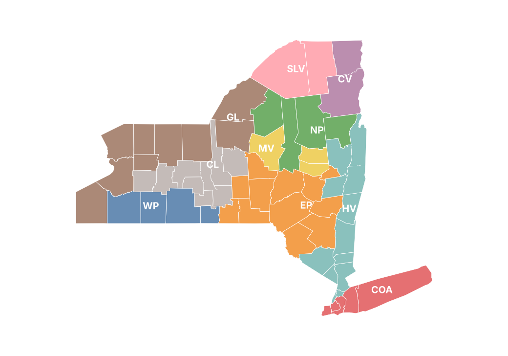
Report climate regions
Monthly precipitation by county (mm)
| County | Jan | Feb | Mar | Apr | May | Jun | Jul | Aug | Sep |
|---|---|---|---|---|---|---|---|---|---|
| Albany | 53.3 | 27.5 | 88.0 | 70.0 | 66.3 | 87.7 | 233.0 | 66.7 | 85.8 |
| Allegany | 57.0 | 32.9 | 124.2 | 175.0 | 99.1 | 90.9 | 127.5 | 65.1 | 105.8 |
| Bronx | 57.4 | 54.3 | 93.8 | 61.2 | 76.8 | 72.2 | 146.7 | 191.5 | 133.0 |
| Broome | 63.1 | 37.4 | 135.1 | 118.4 | 78.2 | 85.9 | 140.2 | 92.8 | 144.5 |
| Cattaraugus | 71.8 | 35.8 | 136.4 | 178.2 | 110.7 | 105.9 | 94.2 | 90.0 | 95.3 |
| Cayuga | 77.9 | 47.5 | 124.2 | 154.7 | 107.4 | 84.6 | 117.1 | 40.8 | 98.3 |
| Chautauqua | 90.0 | 36.2 | 131.9 | 164.2 | 118.0 | 123.4 | 54.9 | 109.6 | 75.5 |
| Chemung | 41.6 | 25.5 | 109.7 | 128.8 | 85.4 | 72.6 | 101.9 | 77.8 | 100.4 |
| Chenango | 69.5 | 39.8 | 120.6 | 128.6 | 80.2 | 73.5 | 136.7 | 93.2 | 123.8 |
| Clinton | 50.8 | 27.5 | 60.1 | 78.8 | 116.4 | 154.6 | 82.7 | 99.8 | 53.0 |
| Columbia | 57.5 | 28.2 | 87.4 | 76.7 | 62.2 | 67.5 | 233.8 | 72.1 | 95.6 |
| Cortland | 71.1 | 47.5 | 116.3 | 147.4 | 85.6 | 78.5 | 144.9 | 69.5 | 127.9 |
| Delaware | 61.8 | 35.6 | 100.1 | 107.1 | 83.4 | 86.8 | 175.8 | 88.7 | 92.2 |
| Dutchess | 44.2 | 29.9 | 95.9 | 68.2 | 58.2 | 45.7 | 183.1 | 93.0 | 119.9 |
| Erie | 104.9 | 38.0 | 135.5 | 177.1 | 112.7 | 116.9 | 63.2 | 108.6 | 76.2 |
| Essex | 72.7 | 43.3 | 79.0 | 92.2 | 122.9 | 120.3 | 99.1 | 100.4 | 59.1 |
| Franklin | 63.0 | 38.5 | 76.8 | 99.0 | 105.8 | 159.9 | 116.1 | 109.7 | 73.6 |
| Fulton | 79.7 | 40.9 | 115.6 | 81.6 | 94.4 | 108.2 | 138.5 | 75.6 | 87.5 |
| Genesee | 83.4 | 36.8 | 117.8 | 154.2 | 108.1 | 117.3 | 101.9 | 101.4 | 98.1 |
| Greene | 53.0 | 33.8 | 89.5 | 89.1 | 66.1 | 76.0 | 232.8 | 83.8 | 88.0 |
| Hamilton | 90.4 | 46.3 | 103.5 | 108.2 | 125.8 | 89.2 | 87.6 | 74.8 | 71.5 |
| Herkimer | 99.9 | 42.7 | 130.1 | 126.5 | 110.4 | 82.5 | 84.5 | 82.2 | 93.5 |
| Jefferson | 129.0 | 45.5 | 123.1 | 133.3 | 83.4 | 95.2 | 87.2 | 107.9 | 60.6 |
| Kings | 60.9 | 62.7 | 91.6 | 62.4 | 78.2 | 65.7 | 139.6 | 214.2 | 133.1 |
| Lewis | 133.0 | 44.7 | 130.9 | 145.3 | 102.2 | 82.9 | 88.7 | 98.9 | 80.6 |
| Livingston | 59.1 | 34.1 | 104.9 | 157.5 | 102.0 | 93.7 | 103.8 | 69.0 | 97.2 |
| Madison | 74.9 | 46.2 | 110.1 | 137.4 | 94.1 | 83.2 | 111.6 | 73.4 | 95.6 |
| Monroe | 80.3 | 42.5 | 121.1 | 138.6 | 103.1 | 104.6 | 119.0 | 72.2 | 73.3 |
| Montgomery | 58.6 | 33.8 | 109.0 | 71.1 | 76.9 | 98.3 | 168.3 | 82.1 | 79.6 |
| Nassau | 51.7 | 47.4 | 90.9 | 54.2 | 80.0 | 48.4 | 165.4 | 165.8 | 127.2 |
| New York | 59.2 | 58.4 | 94.4 | 62.9 | 76.2 | 73.1 | 142.9 | 212.0 | 133.3 |
| Niagara | 78.2 | 33.2 | 116.5 | 163.7 | 105.1 | 106.8 | 103.2 | 141.6 | 83.8 |
| Oneida | 98.8 | 45.0 | 132.0 | 138.6 | 105.7 | 78.8 | 72.6 | 70.6 | 98.8 |
| Onondaga | 83.3 | 48.2 | 132.3 | 144.3 | 110.0 | 89.0 | 89.5 | 43.9 | 92.4 |
| Ontario | 57.7 | 43.6 | 108.4 | 144.2 | 103.0 | 84.4 | 103.2 | 46.7 | 93.9 |
| Orange | 42.1 | 23.3 | 111.6 | 66.4 | 66.4 | 48.2 | 190.1 | 139.0 | 130.5 |
| Orleans | 78.9 | 37.8 | 118.0 | 151.8 | 113.0 | 120.6 | 110.3 | 109.4 | 91.8 |
| Oswego | 122.0 | 48.4 | 152.5 | 129.9 | 106.1 | 90.2 | 70.5 | 56.8 | 71.2 |
| Otsego | 63.7 | 39.0 | 124.5 | 99.5 | 86.2 | 83.6 | 145.7 | 104.3 | 85.3 |
| Putnam | 52.0 | 37.7 | 110.9 | 57.2 | 57.5 | 58.2 | 220.5 | 127.4 | 140.0 |
| Queens | 59.6 | 61.4 | 90.7 | 61.2 | 81.4 | 60.7 | 140.3 | 197.9 | 128.0 |
| Rensselaer | 52.2 | 21.8 | 100.0 | 70.4 | 71.4 | 81.7 | 213.9 | 60.9 | 94.7 |
| Richmond | 60.4 | 55.8 | 88.7 | 61.8 | 75.9 | 62.6 | 149.4 | 223.8 | 151.2 |
| Rockland | 55.1 | 35.4 | 110.7 | 60.1 | 68.3 | 76.4 | 210.4 | 176.7 | 145.4 |
| St. Lawrence | 79.9 | 36.0 | 84.5 | 114.2 | 82.6 | 116.4 | 107.1 | 98.8 | 68.2 |
| Saratoga | 66.2 | 31.5 | 99.9 | 66.6 | 81.6 | 109.2 | 175.8 | 61.5 | 82.9 |
| Schenectady | 55.9 | 28.0 | 93.4 | 64.3 | 69.3 | 101.0 | 218.3 | 62.3 | 87.3 |
| Schoharie | 45.7 | 33.9 | 98.8 | 82.0 | 68.6 | 92.7 | 183.3 | 87.0 | 76.1 |
| Schuyler | 39.8 | 30.9 | 104.7 | 129.4 | 93.4 | 77.9 | 100.0 | 66.9 | 84.3 |
| Seneca | 54.7 | 40.8 | 104.5 | 123.3 | 105.0 | 88.2 | 110.9 | 38.1 | 95.3 |
| Steuben | 44.0 | 30.9 | 104.8 | 151.2 | 92.7 | 79.3 | 113.8 | 62.5 | 95.0 |
| Suffolk | 59.0 | 45.3 | 99.7 | 48.0 | 80.8 | 34.5 | 179.5 | 151.8 | 178.8 |
| Sullivan | 65.2 | 27.3 | 113.4 | 108.4 | 88.7 | 56.0 | 208.6 | 108.3 | 110.2 |
| Tioga | 56.2 | 36.9 | 125.9 | 122.7 | 79.9 | 79.5 | 132.7 | 76.8 | 127.7 |
| Tompkins | 53.6 | 39.4 | 106.0 | 153.2 | 87.2 | 78.2 | 147.0 | 52.8 | 118.7 |
| Ulster | 49.5 | 31.8 | 99.1 | 90.0 | 76.1 | 42.5 | 190.9 | 109.8 | 131.1 |
| Warren | 66.1 | 37.1 | 90.3 | 77.6 | 107.0 | 95.1 | 110.7 | 72.0 | 62.3 |
| Washington | 52.6 | 27.4 | 83.8 | 70.5 | 88.2 | 103.2 | 132.3 | 62.1 | 70.2 |
| Wayne | — | — | — | — | — | — | — | — | — |
| Westchester | 54.5 | 38.8 | 103.7 | 55.3 | 66.8 | 68.4 | 211.0 | 150.9 | 144.4 |
| Wyoming | 88.6 | 40.6 | 116.7 | 158.6 | 111.3 | 110.4 | 78.9 | 88.8 | 118.6 |
| Yates | 45.7 | 38.2 | 108.1 | 113.7 | 108.8 | 89.2 | 91.6 | 48.7 | 77.3 |
Source: NOAA NCEI
Monthly maximum temperature by region (°C)
| Region | Jan | Feb | Mar | Apr | May | Jun | Jul | Aug | Sep |
|---|---|---|---|---|---|---|---|---|---|
| Western Plateau | −3.0 | −0.3 | 9.5 | 17.0 | 18.3 | 24.8 | 27.4 | 25.3 | 22.1 |
| Eastern Plateau | −2.9 | −1.5 | 8.2 | 15.8 | 18.4 | 25.0 | 26.8 | 25.4 | 21.2 |
| Northern Plateau | −4.7 | −3.0 | 5.3 | 13.5 | 16.7 | 23.4 | 25.9 | 24.5 | 19.9 |
| Coastal | 2.4 | 2.2 | 10.9 | 16.3 | 20.1 | 26.8 | 28.2 | 27.9 | 23.7 |
| Hudson Valley | −0.9 | 0.3 | 9.7 | 16.9 | 20.3 | 26.8 | 28.2 | 27.4 | 22.5 |
| Mohawk Valley | −3.4 | −2.0 | 7.3 | 15.4 | 18.4 | 25.2 | 27.3 | 26.0 | 21.6 |
| Champlain Valley | −5.3 | −3.0 | 5.1 | 13.1 | 16.8 | 23.9 | 26.3 | 24.4 | 19.8 |
| St. Lawrence Valley | −5.3 | −3.2 | 5.6 | 13.4 | 17.2 | 24.2 | 26.4 | 24.8 | 20.3 |
| Great Lakes | −3.0 | −1.1 | 8.3 | 15.6 | 17.9 | 24.1 | 27.0 | 25.5 | 22.2 |
| Central Lakes | −2.6 | −0.8 | 8.8 | 16.0 | 18.2 | 24.5 | 27.2 | 25.4 | 21.8 |
Source: NOAA NCEI
Monthly mean temperature by region (°C)
| Region | Jan | Feb | Mar | Apr | May | Jun | Jul | Aug | Sep |
|---|---|---|---|---|---|---|---|---|---|
| Western Plateau | −7.0 | −5.3 | 3.1 | 10.1 | 11.7 | 18.2 | 21.1 | 19.2 | 16.3 |
| Eastern Plateau | −7.1 | −6.5 | 2.3 | 8.9 | 11.9 | 18.0 | 20.6 | 19.3 | 15.8 |
| Northern Plateau | −9.3 | −8.9 | −0.7 | 6.8 | 10.6 | 16.8 | 19.4 | 18.4 | 14.2 |
| Coastal | −1.6 | −1.9 | 6.0 | 10.8 | 15.3 | 21.4 | 23.6 | 23.6 | 19.6 |
| Hudson Valley | −5.5 | −5.3 | 3.8 | 10.1 | 14.1 | 20.0 | 22.2 | 21.5 | 17.4 |
| Mohawk Valley | −7.8 | −7.2 | 1.3 | 8.5 | 12.0 | 18.3 | 20.9 | 19.8 | 15.9 |
| Champlain Valley | −9.6 | −9.2 | −0.7 | 6.5 | 11.0 | 17.6 | 20.0 | 18.6 | 14.3 |
| St. Lawrence Valley | −10.0 | −9.0 | −0.4 | 6.9 | 11.4 | 18.0 | 20.3 | 19.0 | 14.5 |
| Great Lakes | −6.7 | −5.7 | 2.6 | 9.4 | 12.2 | 18.6 | 21.7 | 20.5 | 17.0 |
| Central Lakes | −6.2 | −5.2 | 3.0 | 9.5 | 12.3 | 18.6 | 21.6 | 19.9 | 16.6 |
Source: NOAA NCEI
Monthly minimum temperature by region (°C)
| Region | Jan | Feb | Mar | Apr | May | Jun | Jul | Aug | Sep |
|---|---|---|---|---|---|---|---|---|---|
| Western Plateau | −11.0 | −10.3 | −3.2 | 3.2 | 5.1 | 11.6 | 14.7 | 13.1 | 10.4 |
| Eastern Plateau | −11.3 | −11.6 | −3.6 | 2.1 | 5.5 | 11.1 | 14.3 | 13.2 | 10.4 |
| Northern Plateau | −13.9 | −14.7 | −6.7 | 0.0 | 4.4 | 10.2 | 13.0 | 12.2 | 8.4 |
| Coastal | −5.6 | −6.0 | 1.1 | 5.3 | 10.6 | 15.9 | 18.9 | 19.3 | 15.5 |
| Hudson Valley | −10.2 | −10.8 | −2.2 | 3.4 | 7.8 | 13.3 | 16.2 | 15.5 | 12.2 |
| Mohawk Valley | −12.2 | −12.4 | −4.7 | 1.6 | 5.6 | 11.4 | 14.5 | 13.6 | 10.2 |
| Champlain Valley | −14.0 | −15.4 | −6.6 | −0.2 | 5.1 | 11.2 | 13.8 | 12.8 | 8.7 |
| St. Lawrence Valley | −14.6 | −14.7 | −6.4 | 0.4 | 5.6 | 11.7 | 14.2 | 13.2 | 8.7 |
| Great Lakes | −10.4 | −10.4 | −3.0 | 3.2 | 6.6 | 13.0 | 16.3 | 15.4 | 11.8 |
| Central Lakes | −9.7 | −9.5 | −2.9 | 2.9 | 6.4 | 12.7 | 15.9 | 14.4 | 11.4 |
Source: NOAA NCEI
Stations used
| Id | Name | County | Latitude | Longitude | Altitude (m) | Days with data (Tmax) (%) |
|---|---|---|---|---|---|---|
| USC00300055 | Albion | Orleans | 43.2 | −78.2 | 183.8 | 100.0 |
| USC00300063 | Alcove Dam | Albany | 42.5 | −73.9 | 191.4 | 77.0 |
| USC00300085 | Alfred | Allegany | 42.3 | −77.8 | 586.4 | 37.0 |
| USC00300093 | Allegany Sp | Cattaraugus | 42.1 | −78.7 | 457.2 | 93.0 |
| USC00300183 | Angelica | Allegany | 42.3 | −78.0 | 449.6 | 87.0 |
| USC00300220 | Arcade | Wyoming | 42.5 | −78.5 | 434.9 | 0.0 |
| USC00300321 | Auburn | Cayuga | 42.9 | −76.5 | 234.7 | 100.0 |
| USC00300343 | Avon | Livingston | 42.9 | −77.8 | 166.1 | 100.0 |
| USC00300364 | Baiting Hollow | Suffolk | 40.9 | −72.7 | 21.3 | 63.0 |
| USC00300443 | Batavia | Genesee | 43.0 | −78.2 | 278.3 | 67.0 |
| USC00300608 | Bennetts Brg | Oswego | 43.5 | −76.0 | 201.2 | 0.0 |
| USC00300785 | Boonville 4 SSW | Oneida | 43.4 | −75.4 | 472.4 | 100.0 |
| USC00300870 | Brewerton Lock 23 | Onondaga | 43.2 | −76.2 | 114.9 | 97.0 |
| USC00300889 | Bridgehampton | Suffolk | 41.0 | −72.3 | 12.8 | 37.0 |
| USC00300910 | Bristol Harbour | Ontario | 42.7 | −77.3 | 286.5 | 0.0 |
| USC00300937 | Brockport | Monroe | 43.2 | −78.0 | 151.8 | 97.0 |
| USC00301068 | Buskirk | Rensselaer | 42.9 | −73.4 | 152.1 | 100.0 |
| USC00301102 | Callicoon Ctr | Sullivan | 41.8 | −75.0 | 372.2 | 27.0 |
| USC00301152 | Canandaigua 3 S | Ontario | 42.8 | −77.3 | 219.5 | 100.0 |
| USC00301211 | Carmel 4N | Putnam | 41.5 | −73.7 | 207.3 | 83.0 |
| USC00301264 | Cattaraugus 3W | Cattaraugus | 42.3 | −78.9 | 520.6 | 0.0 |
| USC00301265 | Cayuga Lock #1 | Cayuga | 42.9 | −76.7 | 115.8 | 0.0 |
| USC00301309 | Centerport | Suffolk | 40.9 | −73.4 | 9.1 | 93.0 |
| USC00301388 | Chases Lake | Lewis | 43.8 | −75.3 | 390.4 | 0.0 |
| USC00301580 | Clyde Lock 26 | Wayne | 43.1 | −76.8 | 119.5 | 0.0 |
| USC00301625 | Colden 1W | Erie | 42.6 | −78.7 | 467.9 | 97.0 |
| USC00301708 | Conklingville Dam | Saratoga | 43.3 | −73.9 | 246.3 | 100.0 |
| USC00301752 | Cooperstown | Otsego | 42.7 | −74.9 | 383.1 | 93.0 |
| USC00301787 | Corning | Steuben | 42.1 | −77.1 | 349.6 | 53.0 |
| USC00301974 | Dansville | Livingston | 42.6 | −77.7 | 201.2 | 100.0 |
| USC00302036 | Delhi 2 SE | Delaware | 42.3 | −74.9 | 445.0 | 83.0 |
| USC00302197 | Dunkirk | Chautauqua | 42.5 | −79.3 | 192.3 | 93.0 |
| USC00302454 | E Sidney | Delaware | 42.3 | −75.2 | 352.0 | 93.0 |
| USC00302554 | Elizabethtown | Essex | 44.2 | −73.6 | 186.2 | 0.0 |
| USC00302610 | Elmira | Chemung | 42.1 | −76.8 | 288.6 | 97.0 |
| USC00302934 | Ft Drum | Jefferson | 44.1 | −75.7 | 213.4 | 0.0 |
| USC00303025 | Franklinville | Cattaraugus | 42.3 | −78.5 | 484.6 | 100.0 |
| USC00303050 | Freeville 1 NE | Tompkins | 42.5 | −76.3 | 317.6 | 100.0 |
| USC00303087 | Fulton | Oswego | 43.3 | −76.4 | 109.7 | 0.0 |
| USC00303088 | Fulton Lock O-3 | Oswego | 43.3 | −76.4 | 102.4 | 0.0 |
| USC00303184 | Geneva Rsch Farm | Ontario | 42.9 | −77.0 | 218.8 | 67.0 |
| USC00303322 | Gloversville 7NW (Peck Lake) | Fulton | 43.1 | −74.4 | 443.5 | 100.0 |
| USC00303346 | Gouverneur 3 NW | St. Lawrence | 44.4 | −75.5 | 128.0 | 100.0 |
| USC00303444 | Greene | Chenango | 42.3 | −75.8 | 280.4 | 0.0 |
| USC00303773 | Hemlock | Livingston | 42.8 | −77.6 | 274.9 | 63.0 |
| USC00303851 | Highmarket 2W | Lewis | 43.6 | −75.6 | 549.9 | 100.0 |
| USC00303983 | Hornell Almond Dam | Steuben | 42.3 | −77.7 | 403.9 | 93.0 |
| USC00304102 | Indian Lake 2SW | Hamilton | 43.8 | −74.3 | 509.0 | 100.0 |
| USC00304174 | Ithaca Cornell Univ | Tompkins | 42.4 | −76.4 | 292.6 | 97.0 |
| USC00304207 | Jamestown 4 ENE | Chautauqua | 42.1 | −79.2 | 381.0 | 67.0 |
| USC00304526 | La Fargeville 4E | Jefferson | 44.2 | −75.9 | 132.6 | 0.0 |
| USC00304537 | Lake Luzerne | Saratoga | 43.3 | −73.8 | 185.9 | 0.0 |
| USC00304555 | Lake Placid 2 S | Essex | 44.3 | −74.0 | 575.5 | 100.0 |
| USC00304564 | Lake View 1NE | Erie | 42.7 | −78.9 | 197.2 | 0.0 |
| USC00304565 | Lakeside | Orleans | 43.4 | −78.3 | 87.8 | 0.0 |
| USC00304566 | Lakeville | Livingston | 42.8 | −77.7 | 250.2 | 0.0 |
| USC00304575 | Lansing Manor | Schoharie | 42.4 | −74.5 | 338.3 | 70.0 |
| USC00304684 | Le Roy 1E | Genesee | 43.0 | −78.0 | 272.8 | 0.0 |
| USC00304715 | Lewiston | Niagara | 43.2 | −79.0 | 108.2 | 0.0 |
| USC00304808 | Little Valley | Cattaraugus | 42.2 | −78.8 | 495.3 | 100.0 |
| USC00304844 | Lockport 2SE | Niagara | 43.2 | −78.7 | 195.7 | 100.0 |
| USC00304912 | Lowville | Lewis | 43.8 | −75.5 | 263.0 | 100.0 |
| USC00304952 | Macedon Lock E30 | Wayne | 43.1 | −77.3 | 142.0 | 0.0 |
| USC00304996 | Malone | Franklin | 44.8 | −74.3 | 267.6 | 100.0 |
| USC00305236 | Medina | Orleans | 43.2 | −78.4 | 164.0 | 0.0 |
| USC00305280 | Mexico 2SW | Oswego | 43.4 | −76.3 | 129.5 | 0.0 |
| USC00305426 | Mohonk Lake | Ulster | 41.8 | −74.2 | 336.5 | 0.0 |
| USC00305512 | Morrisville 6 SW | Madison | 42.8 | −75.7 | 512.4 | 50.0 |
| USC00305597 | Mt Morris 2W | Livingston | 42.7 | −77.9 | 268.2 | 93.0 |
| USC00305606 | Mt Sinai | Suffolk | 40.9 | −73.0 | 15.2 | 0.0 |
| USC00305679 | Newark | Wayne | 43.0 | −77.1 | 131.1 | 0.0 |
| USC00305714 | Newcomb | Essex | 44.0 | −74.2 | 502.0 | 87.0 |
| USC00305715 | Newfane | Niagara | 43.3 | −78.7 | 104.2 | 0.0 |
| USC00305840 | Niagara Falls | Niagara | 43.1 | −79.0 | 179.2 | 0.0 |
| USC00305925 | N Creek 5 SE | Warren | 43.7 | −73.9 | 271.3 | 0.0 |
| USC00306047 | N Tonawanda | Niagara | 43.1 | −78.9 | 176.2 | 97.0 |
| USC00306062 | Northville | Fulton | 43.2 | −74.2 | 240.8 | 0.0 |
| USC00306085 | Norwich | Chenango | 42.5 | −75.5 | 301.4 | 93.0 |
| USC00306184 | Old Forge | Herkimer | 43.7 | −75.0 | 520.0 | 0.0 |
| USC00306196 | Olean | Cattaraugus | 42.1 | −78.5 | 432.8 | 93.0 |
| USC00306276 | Orient Pt Sp | Suffolk | 41.1 | −72.3 | 0.9 | 0.0 |
| USC00306314 | Oswego | Oswego | 43.5 | −76.5 | 98.8 | 100.0 |
| USC00306376 | Palermo 2SSE | Oswego | 43.3 | −76.3 | 135.6 | 0.0 |
| USC00306465 | Pavilion 2 | Genesee | 42.9 | −78.0 | 353.6 | 0.0 |
| USC00306480 | Pendleton 1NE | Niagara | 43.1 | −78.7 | 179.5 | 0.0 |
| USC00306525 | Perrysburg | Cattaraugus | 42.5 | −79.0 | 368.8 | 77.0 |
| USC00306747 | Portland 1SW | Chautauqua | 42.4 | −79.5 | 246.3 | 40.0 |
| USC00306774 | Port Jervis | Orange | 41.4 | −74.7 | 176.8 | 80.0 |
| USC00306867 | Pulaski | Oswego | 43.6 | −76.1 | 121.6 | 17.0 |
| USC00307134 | Riverhead Rsch Farm | Suffolk | 41.0 | −72.7 | 30.5 | 70.0 |
| USC00307274 | Rosendale 2 E | Ulster | 41.8 | −74.0 | 37.2 | 0.0 |
| USC00307329 | Rushford | Allegany | 42.4 | −78.2 | 463.9 | 0.0 |
| USC00307425 | Sanborn 4NE | Niagara | 43.2 | −78.8 | 192.9 | 0.0 |
| USC00307484 | Saratoga Springs 4 SW | Saratoga | 43.0 | −73.8 | 99.4 | 0.0 |
| USC00307705 | Sherburne | Chenango | 42.7 | −75.5 | 333.8 | 97.0 |
| USC00307742 | Shrub Oak | Westchester | 41.3 | −73.8 | 140.8 | 97.0 |
| USC00307749 | Silver Springs 3N | Wyoming | 42.7 | −78.1 | 508.1 | 0.0 |
| USC00307750 | Silver Creek | Chautauqua | 42.5 | −79.2 | 198.1 | 0.0 |
| USC00307780 | Skaneateles | Onondaga | 42.9 | −76.4 | 266.7 | 0.0 |
| USC00307842 | Sodus 1W | Wayne | 43.2 | −77.1 | 135.3 | 0.0 |
| USC00308132 | Springville 5NE | Erie | 42.5 | −78.6 | 515.4 | 0.0 |
| USC00308248 | Stillwater Rsvr | Herkimer | 43.9 | −75.0 | 515.1 | 0.0 |
| USC00308577 | Syosset | Nassau | 40.8 | −73.5 | 80.8 | 0.0 |
| USC00308578 | Trenton Falls | Herkimer | 43.3 | −75.2 | 243.8 | 77.0 |
| USC00308600 | Troy L&D | Rensselaer | 42.8 | −73.7 | 4.6 | 0.0 |
| USC00308631 | Tupper Lake Sunmount | Franklin | 44.2 | −74.4 | 512.1 | 33.0 |
| USC00308721 | Upton Coop - Nwsfo New York | Suffolk | 40.9 | −72.9 | 24.4 | 97.0 |
| USC00308839 | Victor 2NW | Ontario | 43.0 | −77.4 | 199.3 | 0.0 |
| USC00308910 | Wales | Erie | 42.7 | −78.5 | 342.9 | 93.0 |
| USC00308932 | Walton 2 | Delaware | 42.2 | −75.1 | 451.1 | 97.0 |
| USC00308961 | Warsaw 4 W | Wyoming | 42.7 | −78.2 | 533.4 | 0.0 |
| USC00308962 | Warsaw 6 SW | Wyoming | 42.7 | −78.2 | 554.7 | 93.0 |
| USC00309000 | Watertown | Jefferson | 44.0 | −75.9 | 151.5 | 0.0 |
| USC00309047 | Waverly | Tioga | 42.0 | −76.5 | 243.8 | 0.0 |
| USC00309049 | Webster 2 NE | Monroe | 43.2 | −77.4 | 83.8 | 97.0 |
| USC00309072 | Wellsville | Allegany | 42.1 | −77.9 | 460.2 | 90.0 |
| USC00309089 | W Bloomfield 1 S | Ontario | 42.9 | −77.5 | 301.8 | 0.0 |
| USC00309248 | Westmoreland 4N | Oneida | 43.2 | −75.5 | 172.2 | 0.0 |
| USC00309389 | Whitehall | Washington | 43.6 | −73.4 | 36.3 | 0.0 |
| USC00309442 | Whitney Pt Dam | Broome | 42.3 | −76.0 | 317.0 | 100.0 |
| USC00309499 | Wilmington 2W | Essex | 44.4 | −73.9 | 615.7 | 0.0 |
| USC00309593 | Wyoming 3W | Wyoming | 42.8 | −78.1 | 475.2 | 100.0 |
| USC00309690 | Youngstown 1S | Niagara | 43.2 | −79.1 | 91.4 | 0.0 |
| USW00004720 | Jamestown | Chautauqua | 42.1 | −79.2 | 525.2 | 0.0 |
| USW00004724 | Niagara Falls Intl AP | Niagara | 43.1 | −78.9 | 178.3 | 100.0 |
| USW00004725 | Binghamton | Broome | 42.2 | −76.0 | 519.1 | 100.0 |
| USW00004742 | Plattsburgh Intl AP | Clinton | 44.6 | −73.5 | 71.9 | 100.0 |
| USW00004781 | Islip-Li Macarthur AP | Suffolk | 40.8 | −73.1 | 25.3 | 100.0 |
| USW00004789 | Montgomery Orange Co AP | Orange | 41.5 | −74.3 | 108.2 | 90.0 |
| USW00014714 | Stewart Fld | Orange | 41.5 | −74.1 | 177.1 | 100.0 |
| USW00014715 | Wheeler Sack Fld Aaf | Jefferson | 44.0 | −75.7 | 214.0 | 0.0 |
| USW00014719 | Westhampton Gabreski AP | Suffolk | 40.9 | −72.6 | 13.1 | 97.0 |
| USW00014732 | Laguardia AP | Queens | 40.8 | −73.9 | 3.0 | 100.0 |
| USW00014733 | Buffalo | Erie | 42.9 | −78.7 | 240.8 | 100.0 |
| USW00014735 | Albany Intl AP | Albany | 42.7 | −73.8 | 85.3 | 100.0 |
| USW00014747 | Dunkirk Chautauqua Co AP | Chautauqua | 42.5 | −79.3 | 203.9 | 97.0 |
| USW00014748 | Elmira Corning Rgnl AP | Chemung | 42.2 | −76.9 | 285.3 | 93.0 |
| USW00014750 | Glens Falls AP | Warren | 43.3 | −73.6 | 97.8 | 100.0 |
| USW00014757 | Poughkeepsie AP | Dutchess | 41.6 | −73.9 | 46.6 | 100.0 |
| USW00014768 | Rochester Gtr Intl | Monroe | 43.1 | −77.7 | 164.6 | 100.0 |
| USW00014771 | Syracuse Hancock Intl AP | Onondaga | 43.1 | −76.1 | 125.0 | 100.0 |
| USW00054746 | Monticello Sullivan | Sullivan | 41.7 | −74.8 | 427.6 | 0.0 |
| USW00054757 | Wellsville Muni AP | Allegany | 42.1 | −78.0 | 637.6 | 97.0 |
| USW00054773 | Fulton Oswego Co AP | Oswego | 43.4 | −76.4 | 143.6 | 97.0 |
| USW00054778 | Penn Yan AP | Yates | 42.6 | −77.1 | 267.3 | 97.0 |
| USW00054780 | Montauk AP | Suffolk | 41.1 | −71.9 | 2.1 | 100.0 |
| USW00054787 | Farmingdale Republic AP | Suffolk | 40.7 | −73.4 | 22.9 | 93.0 |
| USW00054790 | Shirley Brookhaven AP | Suffolk | 40.8 | −72.9 | 20.1 | 90.0 |
| USW00064756 | Millbrook 3 W | Dutchess | 41.8 | −73.7 | 125.9 | 100.0 |
| USW00064758 | Ithaca 13 E | Cortland | 42.4 | −76.2 | 374.3 | 100.0 |
| USW00064775 | Rome Griffiss Airfield | Oneida | 43.2 | −75.4 | 144.8 | 97.0 |
| USW00064776 | Plattsburgh Intl AP | Clinton | 44.6 | −73.5 | 50.3 | 100.0 |
| USW00094704 | Dansville Muni AP | Livingston | 42.6 | −77.7 | 196.0 | 97.0 |
| USW00094725 | Massena Intl AP | St. Lawrence | 44.9 | −74.8 | 61.0 | 100.0 |
| USW00094728 | Ny City Cntrl Park | New York | 40.8 | −74.0 | 42.7 | 100.0 |
| USW00094740 | Saranac Lk Adirondack Rgnl AP | Franklin | 44.4 | −74.2 | 505.7 | 100.0 |
| USW00094745 | Westchester Co AP | Westchester | 41.1 | −73.7 | 112.8 | 90.0 |
| USW00094789 | Jfk Intl AP | Queens | 40.6 | −73.8 | 2.7 | 100.0 |
| USW00094790 | Watertown AP | Jefferson | 44.0 | −76.0 | 94.8 | 100.0 |
Source: NOAA NCEI
11 Glossary, methodology and sources
Anomaly: difference between the observed value and its 1991–2020 normal. Percent of normal: observed total divided by the normal, times 100. Station record: most extreme daily value for the same month in all earlier years of record (at least 20 years).
Temperature: NOAA nClimGrid-Daily. Precipitation: NOAA nClimGrid-Daily. nClimGrid-Daily is the grid behind NOAA's official statewide values; it is averaged here from 1/24° to 1/8° (about 12 km). Mean temperature is (Tmax + Tmin)/2. Statewide, regional and county averages are weighted by the area of each grid cell inside each polygon. Temperature maps, frost days and annex tables are given by region; regions are NOAA NCEI climate divisions, with each county in the division of its centroid. Recent weeks use NCEI's preliminary file of the month; such reports are marked preliminary and updated when the final file is published. Normals refer to 1991-2020; ranks compare values rounded to one decimal. Stations: GHCN-Daily (NOAA NCEI) cooperative and first-order stations; values flagged by its quality control are discarded, as are daily values more than 5 robust standard deviations from the station median and variables whose monthly anomaly differs by more than 3 °C from the gridded analysis. Period means require at least 80% of days with data and station normals at least 20 complete years. This report is generated automatically and does not replace official information from the National Weather Service or the state climatologist.
| Source | Product | License | Citation |
|---|---|---|---|
| NOAA CPC | Official ENSO probabilities | Public domain (NOAA) | — |
| NOAA CPC | ONI, Niño-region SST indices (OISST v2.1), NAO and AO | Public domain (NOAA) | NOAA Climate Prediction Center climate indices. |
| NOAA NCEI / PSL | Extended Reconstructed SST v5 (ERSST v5), 2° | Public domain (NOAA) | Huang et al. (2017), J. Climate, doi:10.1175/JCLI-D-16-0836.1 |
| GDACS | Global Disaster Alert and Coordination System event list | See provider terms | — |
| NOAA NCEI | GHCN-Daily | Public domain (NOAA) | Menne et al. (2012), J. Atmos. Oceanic Technol., doi:10.1175/JTECH-D-11-00103.1 |
| NOAA NCEI | IBTrACS v04r01 tropical-cyclone best tracks | Public domain (NOAA) | Knapp et al. (2010), Bull. Amer. Meteor. Soc., doi:10.1175/2009BAMS2755.1 |
| NOAA NCEI | Pacific Decadal Oscillation index (ERSST v5) | Public domain (NOAA) | — |
| NOAA NCEI | nClimGrid-Daily, contiguous United States (1/24°, averaged here to 1/8°) | Public domain (NOAA) | Durre, I., et al. (2022). NOAA's nClimGrid-Daily Version 1. NOAA National Centers for Environmental Information. doi:10.25921/c4gt-r169 |
| NOAA CPC | North American Multi-Model Ensemble (NMME) tercile probabilities, 1° | Public domain (NOAA) | Kirtman et al. (2014), Bull. Amer. Meteor. Soc., doi:10.1175/BAMS-D-12-00050.1 |
| NOAA PSL | Real-time OLR MJO Index (ROMI) | Public domain (NOAA) | Kiladis et al. (2014), Mon. Wea. Rev., doi:10.1175/MWR-D-13-00301.1 |
| National Drought Mitigation Center, USDA, NOAA | U.S. Drought Monitor, weekly maps and area statistics | Free to use with credit (NDMC) | The U.S. Drought Monitor is jointly produced by the National Drought Mitigation Center at the University of Nebraska-Lincoln, the United States Department of Agriculture and the National Oceanic and Atmospheric Administration. Map courtesy of NDMC. |
| US Census Bureau TIGERweb | US Census Bureau, TIGERweb counties (generalised) | Public domain (US Government work) | — |
Generated by ClimaBulletin (climabulletin.org), open source. Questions and comments: [email protected].