California · Monthly
September 2026
Downloads
1 Key messages and climate synopsis
Source: NOAA NCEI
Source: NOAA NCEI
2 Global and regional climate drivers
Sea-surface temperature anomaly, September 2026 (°C, 1991–2020)
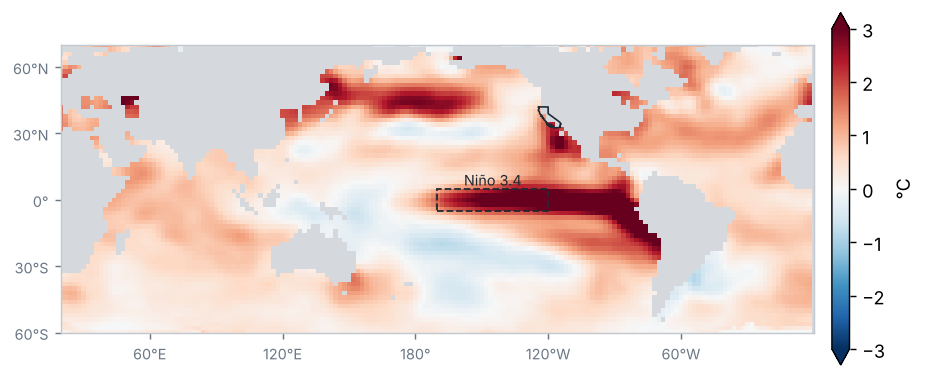
Source: NOAA NCEI / PSL
Sea-surface temperature anomaly in the Niño regions (°C)
| Region | Anomaly (°C) | Change from preceding period (°C) |
|---|---|---|
| Niño 1+2 | 4.7 | 0.6 |
| Niño 3 | 3.6 | 0.5 |
| Niño 3.4 | 2.8 | 0.3 |
| Niño 4 | 0.9 | 0.0 |
Mean of the months in the period (OISST v2.1)
Source: NOAA CPC
El Niño conditions of very strong intensity: the Oceanic Niño Index (ONI) for JAS 2026 was +2.2 °C.
Source: NOAA CPC
Monthly Niño 3.4 anomaly, last 24 months (°C)
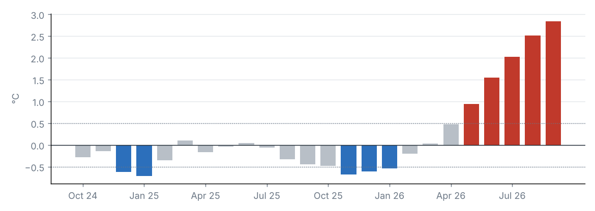
Source: NOAA CPC
MJO phase diagram (real-time OMI)
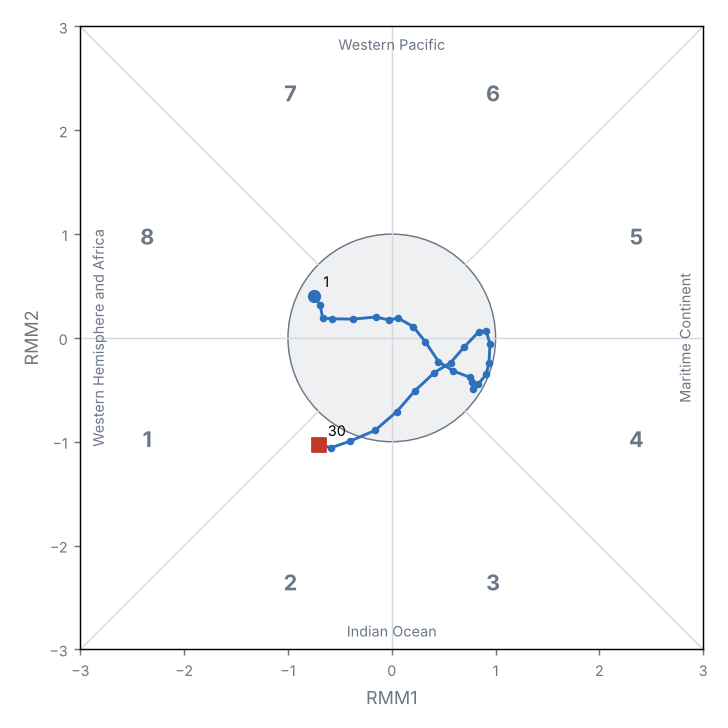
Source: NOAA PSL
Teleconnection indices
| Index | Value | Phase |
|---|---|---|
| NAO | 0.5 | Positive |
| AO | 1.2 | Positive |
| PDO | −1.6 | Negative |
North Atlantic Oscillation (NAO); Arctic Oscillation (AO); Pacific Decadal Oscillation (PDO).
Source: NOAA CPC, NOAA NCEI
The Niño 3.4 anomaly was +2.84 °C (+0.32 °C relative to the preceding period).
The MJO was active on 3 of 30 days, most often in phase 2 (Indian Ocean); mean amplitude 0.7.
Other indices: NAO +0.53 (positive phase); AO +1.16 (positive phase); PDO −1.55 (negative phase).
3 Precipitation
Source: NOAA NCEI
Accumulated precipitation
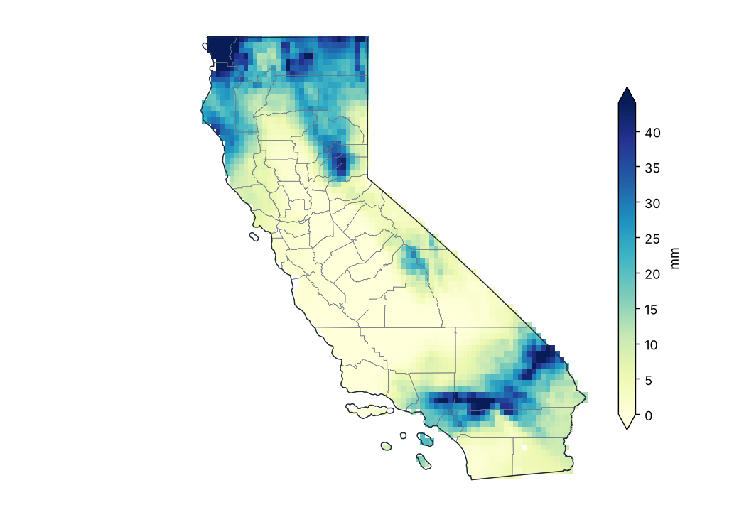
Source: NOAA NCEI
Percent of normal precipitation (1991–2020)
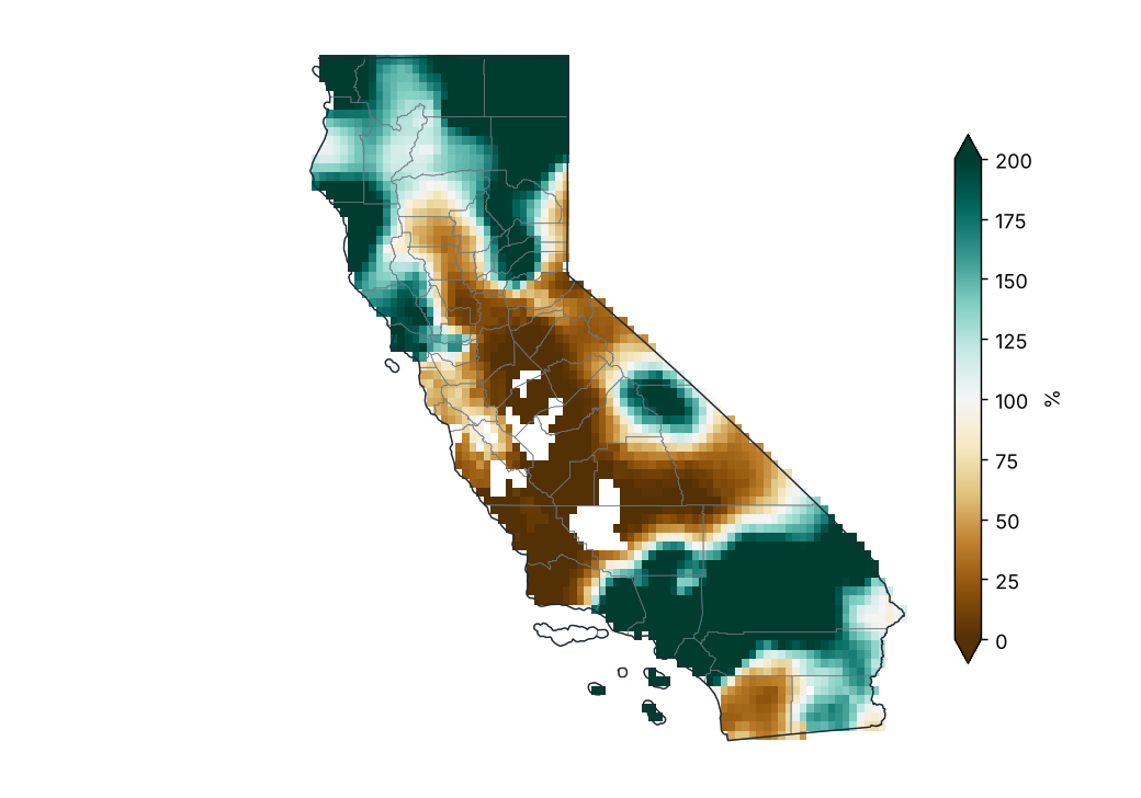
Source: NOAA NCEI
Percent of normal by county
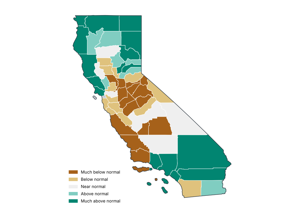
Source: NOAA NCEI
Precipitation by region
| Region | Total (mm) | Normal (mm) | Difference (%) | Category |
|---|---|---|---|---|
| North Coast Drainage | 25.0 | 12.9 | 93.4 | Much above normal |
| Sacramento Drainage | 13.8 | 9.1 | 51.2 | Above normal |
| Northeast Interior Basins | 12.6 | 9.6 | 31.8 | Above normal |
| Central Coast Drainage | 0.6 | 1.7 | −62.4 | Much below normal |
| San Joaquin Drainage | 1.9 | 4.0 | −51.4 | Below normal |
| South Coast Drainage | 8.5 | 3.3 | 159.2 | Much above normal |
| Southeast Desert Basin | 13.8 | 6.4 | 114.6 | Much above normal |
Source: NOAA NCEI
Stations with the largest precipitation excess
| Region | County | Station | Altitude (m) | Anomaly (%) |
|---|---|---|---|---|
| South Coast Drainage | Los Angeles | Torrance AP | 27.0 | 2903.9 |
| South Coast Drainage | Los Angeles | Burbank Glendale Pasadena AP | 223.0 | 1239.6 |
| South Coast Drainage | Los Angeles | Culver City | 28.0 | 1132.5 |
| South Coast Drainage | Los Angeles | Van Nuys AP | 239.0 | 768.6 |
| Southeast Desert Basin | San Bernardino | Chino AP | 194.0 | 768.4 |
| South Coast Drainage | Los Angeles | Long Beach Daugherty AP | 10.0 | 734.4 |
| South Coast Drainage | Los Angeles | U C L A | 131.0 | 689.5 |
| South Coast Drainage | Los Angeles | Santa Monica Muni AP | 53.0 | 546.4 |
| South Coast Drainage | Orange | Fullerton Muni AP | 26.0 | 523.8 |
| South Coast Drainage | Los Angeles | Los Angeles Intl AP | 30.0 | 516.4 |
Source: NOAA NCEI
Stations with the largest precipitation deficit
| Region | County | Station | Altitude (m) | Anomaly (%) |
|---|---|---|---|---|
| San Joaquin Drainage | Kern | Glennville | 957.0 | −100.0 |
| Southeast Desert Basin | Riverside | Hayfield Pumping Plt | 418.0 | −100.0 |
| San Joaquin Drainage | Tulare | Lemon Cove | 156.0 | −100.0 |
| South Coast Drainage | Santa Barbara | Santa Barbara | 5.0 | −100.0 |
| San Joaquin Drainage | Stanislaus | Modesto AP | 26.0 | −100.0 |
| San Joaquin Drainage | Kern | Bakersfield 5 NW | 143.0 | −100.0 |
| Central Coast Drainage | Monterey | Big Sur Stn | 61.0 | −100.0 |
| South Coast Drainage | Los Angeles | Burbank Valley Pump Plt | 200.0 | −100.0 |
| South Coast Drainage | Santa Barbara | Cachuma Lake | 240.0 | −100.0 |
| Sacramento Drainage | Yolo | Davis 2 WSW Exp Farm | 18.0 | −100.0 |
Source: NOAA NCEI
Largest 24-hour rainfall at stations
| Station | County | Max 24 h rainfall (mm) | Date |
|---|---|---|---|
| Bowman Dam | Nevada | 57.5 | 2026-09-04 |
| Downieville | Sierra | 51.8 | 2026-09-03 |
| Crescent City Mcnamara AP | Del Norte | 51.8 | 2026-09-02 |
| Torrance AP | Los Angeles | 39.4 | 2026-09-06 |
| Mccloud | Siskiyou | 36.8 | 2026-09-03 |
| Burbank Glendale Pasadena AP | Los Angeles | 35.8 | 2026-09-06 |
| Strawberry Valley 2 | Butte | 35.6 | 2026-09-04 |
| Joshua Tree | San Bernardino | 33.5 | 2026-09-25 |
| Volta Ph | Shasta | 29.6 | 2026-09-04 |
| Blue Canyon Nyack AP | Placer | 29.2 | 2026-09-04 |
Source: NOAA NCEI
Daily statewide mean precipitation
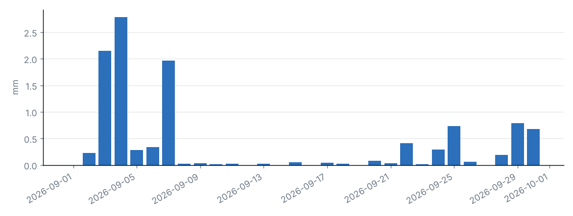
Source: NOAA NCEI
Daily statewide mean and grid-cell maximum
| Day | Statewide mean (mm) | Grid maximum (mm) | County |
|---|---|---|---|
| 2026-09-01 | 0.0 | 1.1 | Tulare |
| 2026-09-02 | 0.2 | 6.4 | Siskiyou |
| 2026-09-03 | 2.2 | 52.4 | Del Norte |
| 2026-09-04 | 2.8 | 37.4 | Modoc |
| 2026-09-05 | 0.3 | 18.1 | Placer |
| 2026-09-06 | 0.3 | 16.0 | San Bernardino |
| 2026-09-07 | 2.0 | 28.5 | San Bernardino |
| 2026-09-08 | 0.0 | 1.9 | Los Angeles |
| 2026-09-09 | 0.0 | 2.4 | Madera |
| 2026-09-10 | 0.0 | 1.5 | Inyo |
| 2026-09-11 | 0.0 | 1.1 | Los Angeles |
| 2026-09-12 | 0.0 | 0.0 | Del Norte |
| 2026-09-13 | 0.0 | 8.3 | Del Norte |
| 2026-09-14 | 0.0 | 0.0 | Del Norte |
| 2026-09-15 | 0.0 | 2.0 | Fresno |
| 2026-09-16 | 0.0 | 0.0 | Del Norte |
| 2026-09-17 | 0.0 | 4.1 | Siskiyou |
| 2026-09-18 | 0.0 | 1.1 | Siskiyou |
| 2026-09-19 | 0.0 | 0.0 | Del Norte |
| 2026-09-20 | 0.1 | 5.7 | Los Angeles |
| 2026-09-21 | 0.0 | 5.4 | Inyo |
| 2026-09-22 | 0.4 | 14.7 | Fresno |
| 2026-09-23 | 0.0 | 1.3 | Tulare |
| 2026-09-24 | 0.3 | 15.2 | San Bernardino |
| 2026-09-25 | 0.7 | 37.0 | Del Norte |
| 2026-09-26 | 0.1 | 2.5 | Siskiyou |
| 2026-09-27 | 0.0 | 0.0 | Del Norte |
| 2026-09-28 | 0.2 | 9.8 | Imperial |
| 2026-09-29 | 0.8 | 26.6 | San Bernardino |
| 2026-09-30 | 0.7 | 19.6 | San Bernardino |
Source: NOAA NCEI
Statewide precipitation in September of each year
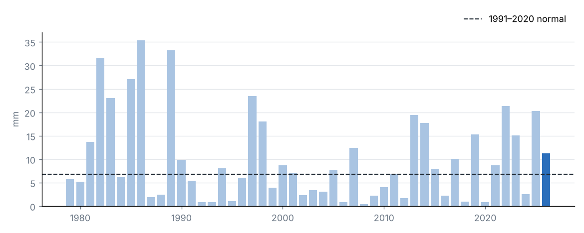
Source: NOAA NCEI
Statewide accumulated precipitation was 11.3 mm, 167% of the 1991–2020 average (6.8 mm), category “Much above normal”. It was the 16th wettest September in the 1979–2026 series.
The region with the highest percentage of normal was South Coast Drainage (259%) and the lowest was Central Coast Drainage (38%).
The largest daily grid-cell total was estimated on 3 September in Del Norte (52.4 mm).
Source: NOAA NCEI
4 Temperature
Source: NOAA NCEI
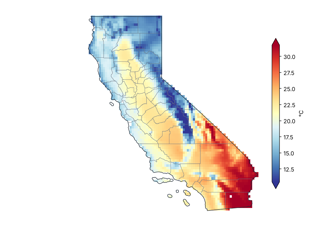
Mean temperature
Source: NOAA NCEI
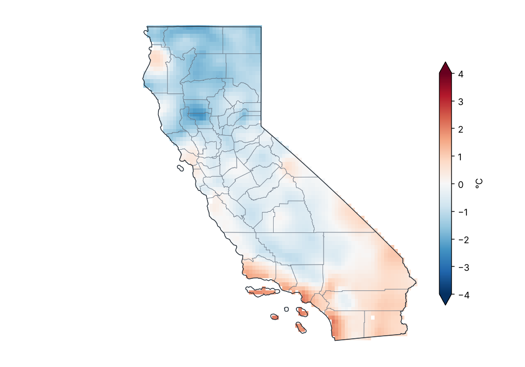
Mean temperature anomaly (1991–2020)
Source: NOAA NCEI
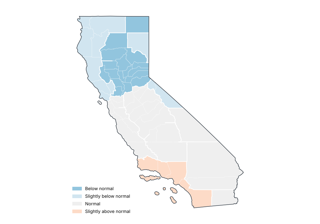
Mean temperature anomaly by region
Source: NOAA NCEI
Stations with the largest positive anomaly
| Region | County | Station | Altitude (m) | Anomaly (°C) |
|---|---|---|---|---|
| South Coast Drainage | Los Angeles | Culver City | 28.0 | 2.9 |
| South Coast Drainage | Los Angeles | Torrance AP | 27.0 | 2.6 |
| South Coast Drainage | Ventura | Oxnard Ventura Co AP | 12.0 | 2.5 |
| South Coast Drainage | Santa Barbara | Santa Barbara Muni AP | 2.0 | 2.5 |
| South Coast Drainage | Los Angeles | Hawthorne Muni AP | 17.0 | 2.4 |
| South Coast Drainage | Santa Barbara | Santa Barbara | 5.0 | 2.4 |
| South Coast Drainage | Los Angeles | Los Angeles Intl AP | 30.0 | 2.3 |
| South Coast Drainage | Los Angeles | Santa Monica Muni AP | 53.0 | 2.2 |
| South Coast Drainage | Ventura | Pt Mugu Nf | 4.0 | 2.2 |
| South Coast Drainage | San Diego | Oceanside Muni AP | 9.0 | 2.1 |
Source: NOAA NCEI
Stations with the largest negative anomaly
| Region | County | Station | Altitude (m) | Anomaly (°C) |
|---|---|---|---|---|
| Sacramento Drainage | Placer | Blue Canyon Nyack AP | 1611.0 | −2.4 |
| North Coast Drainage | Siskiyou | Yreka | 827.0 | −2.3 |
| North Coast Drainage | Siskiyou | Montague Siskiyou AP | 806.0 | −2.3 |
| South Coast Drainage | Los Angeles | Sandberg | 1375.0 | −2.0 |
| Central Coast Drainage | Santa Clara | Mt Hamilton | 1286.0 | −2.0 |
| San Joaquin Drainage | Tuolumne | New Melones Dam Hq | 293.0 | −1.9 |
| San Joaquin Drainage | Fresno | Friant Government Camp | 131.0 | −1.8 |
| San Joaquin Drainage | Tuolumne | Sonora | 510.0 | −1.8 |
| Sacramento Drainage | Tehama | Red Bluff Muni AP | 108.0 | −1.7 |
| Sacramento Drainage | Shasta | Redding AP | 153.0 | −1.6 |
Source: NOAA NCEI
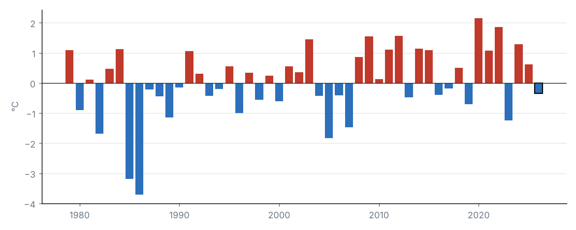
Statewide mean temperature anomaly in September of each year
Source: NOAA NCEI
The statewide mean temperature was 20.8 °C, 0.3 °C below the 1991–2020 average (21.2 °C), category “Normal”. It was the 17th coldest September in the 1979–2026 series (tied with 2006, 2016).
By region, the largest anomaly was in South Coast Drainage (+0.7 °C) and the smallest in Sacramento Drainage (−1.2 °C).
Source: NOAA NCEI
Source: NOAA NCEI
Maximum temperature anomaly (1991–2020)
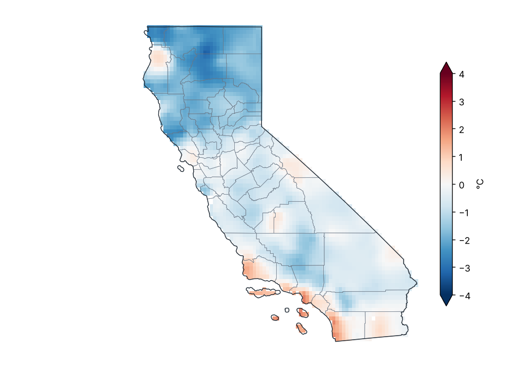
Source: NOAA NCEI
Lowest and highest monthly mean maximum temperature by region
| Region | Lowest value (°C) | Station | Highest value (°C) | Station |
|---|---|---|---|---|
| North Coast Drainage | 18.0 | Arcata Eureka AP | 30.5 | Potter Valley Powerhouse |
| Sacramento Drainage | 19.3 | Tahoma | 31.7 | Winters |
| Central Coast Drainage | 17.8 | San Francisco Oceanside | 31.7 | Tracy Pumping Plt |
| San Joaquin Drainage | 19.8 | Grant Grove | 35.8 | Newman |
| South Coast Drainage | 22.5 | San Nicolas Is | 32.2 | Cachuma Lake |
| Southeast Desert Basin | 19.5 | Aspendell | 41.2 | Death Valley Np |
Station monthly means (GHCN-Daily, ≥ 80% of days with data).
Source: NOAA NCEI
Daily statewide maximum temperature
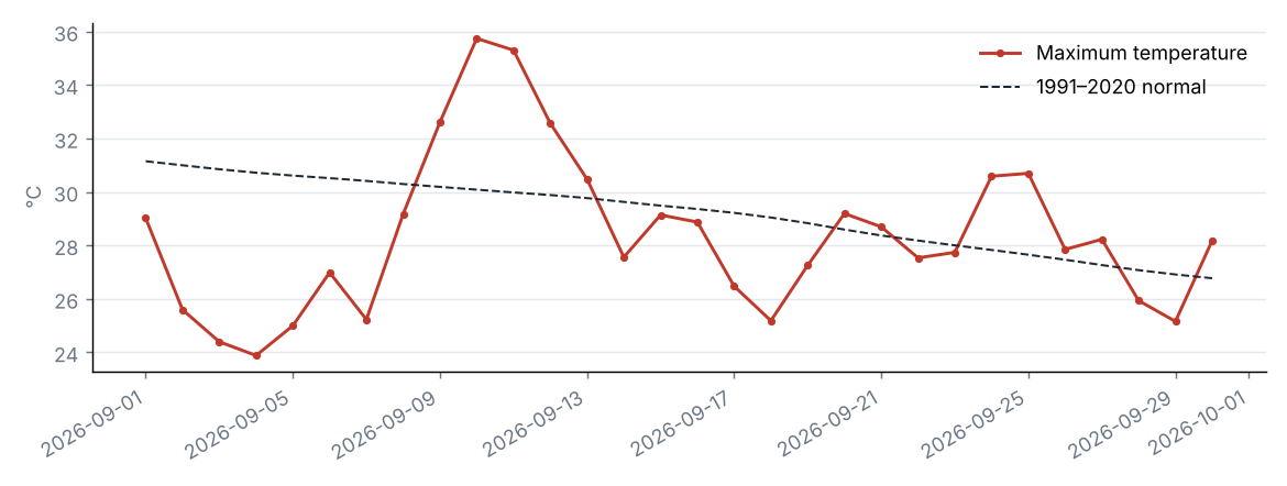
Source: NOAA NCEI
The statewide maximum temperature was 28.3 °C, 0.8 °C below the 1991–2020 average (29.2 °C), category “Slightly below normal”. It was the 11th coldest September in the 1979–2026 series (tied with 1980, 2013, 2017).
By region, the largest anomaly was in South Coast Drainage (+0.2 °C) and the smallest in Sacramento Drainage (−1.7 °C).
Source: NOAA NCEI
Source: NOAA NCEI
Minimum temperature anomaly (1991–2020)
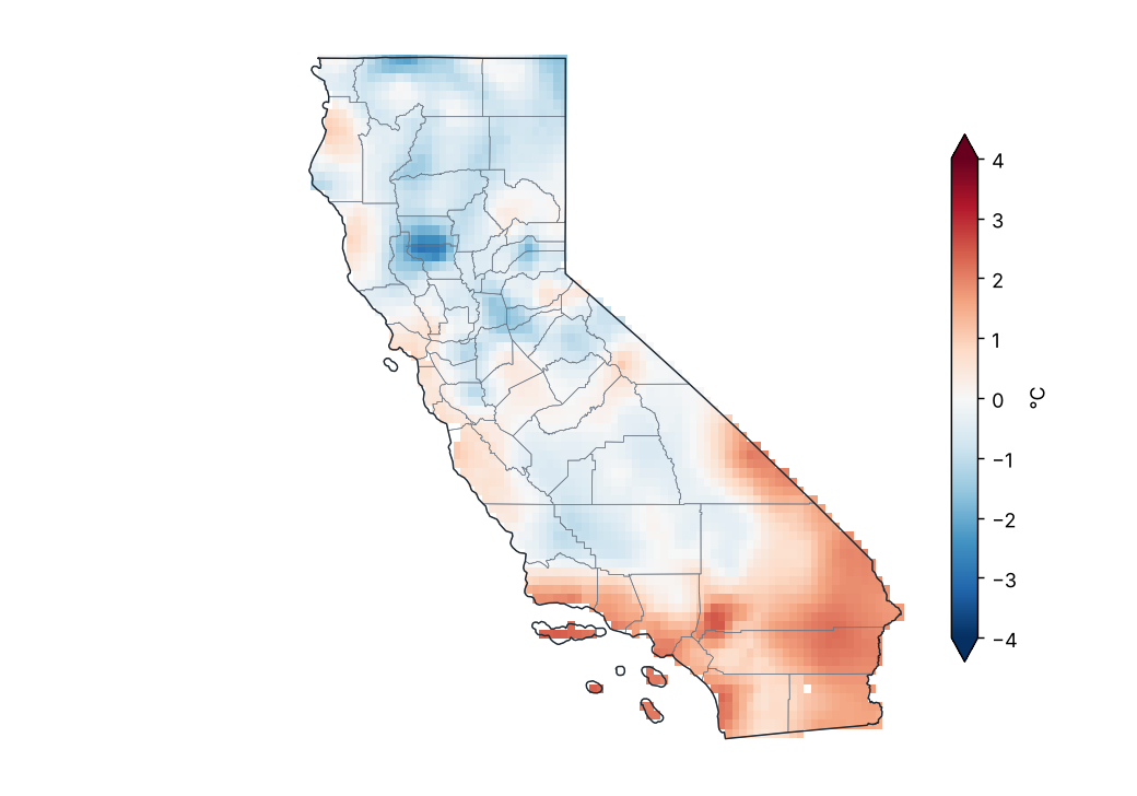
Source: NOAA NCEI
Lowest and highest monthly mean minimum temperature by region
| Region | Lowest value (°C) | Station | Highest value (°C) | Station |
|---|---|---|---|---|
| North Coast Drainage | 5.2 | Ft Jones Rs | 12.6 | San Rafael-Civic Ctr |
| Sacramento Drainage | 2.4 | S Lake Tahoe AP | 14.8 | Oroville Muni AP |
| Central Coast Drainage | 9.2 | Pinnacles Np | 15.3 | Hearst Castle |
| San Joaquin Drainage | 6.1 | Glennville | 17.5 | Bakersfield AP |
| South Coast Drainage | 10.0 | Henshaw Dam | 20.8 | N Is Nas |
| Southeast Desert Basin | 7.0 | Aspendell | 27.5 | Death Valley Np |
Station monthly means (GHCN-Daily, ≥ 80% of days with data).
Source: NOAA NCEI
Daily statewide minimum temperature
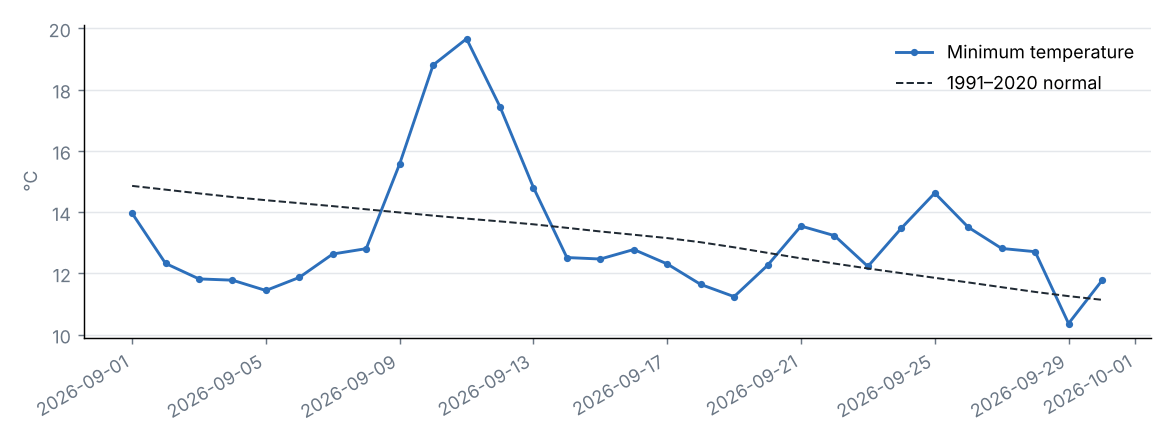
Source: NOAA NCEI
The statewide minimum temperature was 13.3 °C, 0.1 °C above the 1991–2020 average (13.1 °C), category “Normal”. It was the 24th warmest September in the 1979–2026 series.
By region, the largest anomaly was in South Coast Drainage (+1.1 °C) and the smallest in Sacramento Drainage (−0.7 °C).
Source: NOAA NCEI
5 Climate extremes and records
Source: NOAA NCEI
Highest maximum temperature by county
| County | Station | Temperature (°C) | Date |
|---|---|---|---|
| Inyo | Stovepipe Wells 1 SW | 47.3 | 2026-09-10 |
| Imperial | Imperial Co AP | 45.0 | 2026-09-10 |
| Riverside | Blythe Asos | 45.0 | 2026-09-10 |
| San Bernardino | Needles AP | 45.0 | 2026-09-10 |
| Merced | Newman | 43.9 | 2026-09-10 |
| San Diego | Borrego Desert Park | 43.9 | 2026-09-10 |
| Santa Barbara | Cachuma Lake | 42.8 | 2026-09-10 |
| Fresno | Fresno 5 NE | 42.2 | 2026-09-11 |
| Orange | Fullerton Muni AP | 42.2 | 2026-09-09 |
| Yolo | Davis 2 WSW Exp Farm | 42.2 | 2026-09-11 |
| Kern | China Lake Naf | 41.7 | 2026-09-10 |
| Kings | Lemoore Reeves Nas | 41.7 | 2026-09-10 |
| Los Angeles | Long Beach Daugherty AP | 41.7 | 2026-09-09 |
| San Luis Obispo | San Luis Obispo Mcchesney Fld | 41.7 | 2026-09-09 |
| Solano | Vacaville/Nut Tree AP Asos | 41.7 | 2026-09-10 |
| Tulare | Lemon Cove | 41.7 | 2026-09-11 |
| Sacramento | Sacramento Metro AP | 41.1 | 2026-09-10 |
| San Joaquin | Stockton AP | 41.1 | 2026-09-10 |
| Butte | Oroville Muni AP | 40.6 | 2026-09-10 |
| Madera | Madera Muni AP | 40.6 | 2026-09-10 |
The 20 most extreme of 51.
Source: NOAA NCEI
Lowest minimum temperature by county
| County | Station | Temperature (°C) | Date |
|---|---|---|---|
| Nevada | Boca | −3.9 | 2026-09-14 |
| Tuolumne | Tuolumne Meadows Rs | −3.9 | 2026-09-18 |
| Modoc | Alturas Muni AP | −2.8 | 2026-09-28 |
| El Dorado | S Lake Tahoe AP | −2.2 | 2026-09-14 |
| Sierra | Sierraville Rs | −1.1 | 2026-09-21 |
| Siskiyou | Tulelake | −1.1 | 2026-09-14 |
| Placer | Tahoe City | 0.6 | 2026-09-18 |
| Plumas | Quincy | 1.7 | 2026-09-28 |
| Shasta | Dunsmuir Trtmt Pl | 2.2 | 2026-09-27 |
| Inyo | Aspendell | 2.8 | 2026-09-29 |
| Lassen | Susanville 2SW | 2.8 | 2026-09-05 |
| Kern | Glennville | 3.3 | 2026-09-03 |
| Mariposa | So Entrance Yosemite Np | 3.3 | 2026-09-18 |
| Mono | Lee Vining | 3.3 | 2026-09-30 |
| San Bernardino | Barstow | 3.3 | 2026-09-14 |
| San Diego | Campo | 3.3 | 2026-09-19 |
| San Benito | Pinnacles Np | 3.9 | 2026-09-27 |
| Fresno | Friant Government Camp | 4.4 | 2026-09-23 |
| Monterey | Big Sur Stn | 5.0 | 2026-09-28 |
| Tulare | Grant Grove | 5.0 | 2026-09-03 |
The 20 most extreme of 52.
Source: NOAA NCEI
Station records broken
| Station | County | Variable | New value | Date | Previous record | Previous date |
|---|---|---|---|---|---|---|
| Barstow | San Bernardino | Lowest minimum temperature | 3.3 | 2026-09-14 | 4.4 | 1982-09-30 |
| Sonora | Tuolumne | Lowest minimum temperature | 0.6 | 2026-09-18 | 1.7 | 1920-09-25 |
| Burbank Glendale Pasadena AP | Los Angeles | Highest 24 h rainfall | 35.8 | 2026-09-06 | 26.4 | 2015-09-15 |
| Oceanside Muni AP | San Diego | Highest maximum temperature | 37.2 | 2026-09-09 | 36.7 | 2015-09-10 |
Most extreme daily value of the period against the same period in all earlier years of record (at least 20 years; for weeks, the same calendar month).
Source: NOAA NCEI
Climate-extremes indices (statewide mean)
| Index | Description | Value | Normal | Difference | Unit |
|---|---|---|---|---|---|
| TX90p | Warm days (Tmax > 90th percentile) | 7.5 | 10.0 | −2.5 | % |
| TN90p | Warm nights (Tmin > 90th percentile) | 12.6 | 10.0 | 2.6 | % |
| TX10p | Cool days (Tmax < 10th percentile) | 14.0 | 10.0 | 4.0 | % |
| TN10p | Cold nights (Tmin < 10th percentile) | 8.3 | 10.0 | −1.7 | % |
| FD | Frost days (Tmin < 0 °C) | 0.2 | 0.4 | −0.2 | d |
| SU | Summer days (Tmax > 25 °C) | 21.4 | 22.8 | −1.4 | d |
| TR | Tropical nights (Tmin > 20 °C) | 4.6 | 3.9 | 0.7 | d |
| WSDI | Warm spell days (≥ 6 days) | 0.0 | — | — | d |
| CSDI | Cold spell days (≥ 6 days) | 0.2 | — | — | d |
| Rx1day | Maximum 1-day precipitation | 6.8 | 4.1 | 2.7 | mm |
| Rx5day | Maximum 5-day precipitation | 9.0 | 5.8 | 3.2 | mm |
| CDD | Consecutive dry days (< 1 mm) | 24.2 | 25.1 | −0.9 | d |
| CWD | Consecutive wet days (≥ 1 mm) | 1.2 | 0.8 | 0.4 | d |
Percentile indices relative to calendar-day percentiles of 1991–2020 (5-day window); counts and maxima averaged over the state's grid cells.
Source: NOAA NCEI
Frost days by region
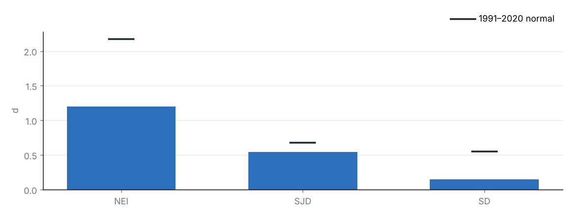
Source: NOAA NCEI
6 Drought
U.S. Drought Monitor, 29 September 2026
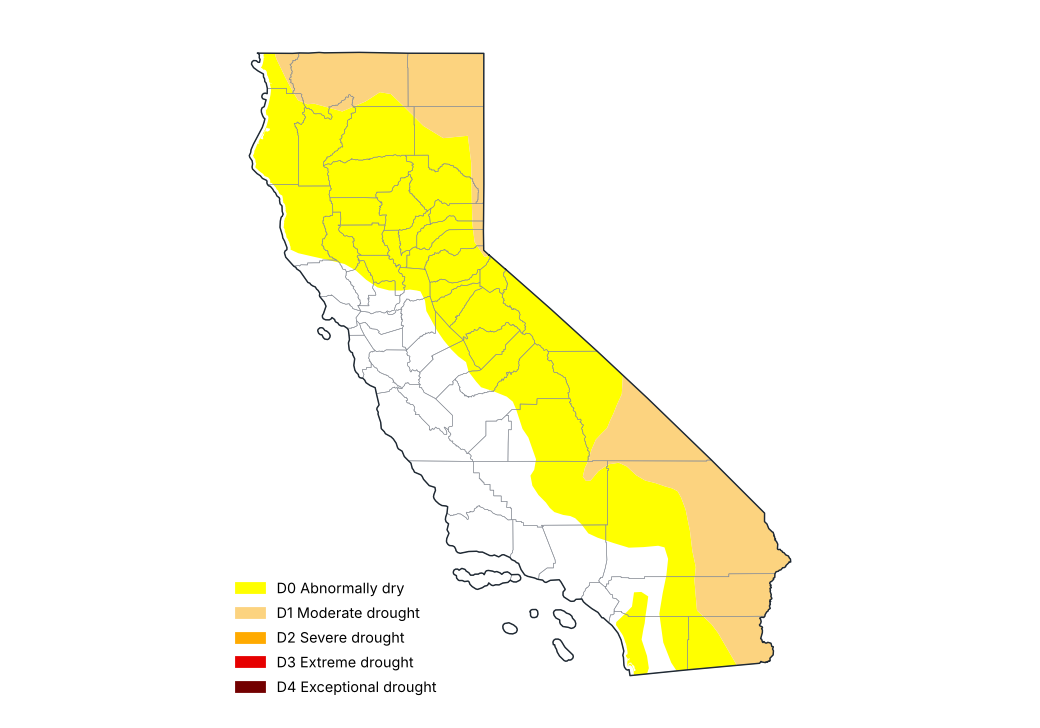
Source: National Drought Mitigation Center, USDA, NOAA
Share of the state by drought category, weekly U.S. Drought Monitor maps (%)
| Map of | None (%) | D0–D4 (%) | D1–D4 (%) | D2–D4 (%) | D3–D4 (%) | D4 (%) |
|---|---|---|---|---|---|---|
| 2026-09-01 | 34.8 | 65.2 | 18.8 | 1.3 | 0.0 | 0.0 |
| 2026-09-08 | 34.8 | 65.2 | 18.8 | 1.3 | 0.0 | 0.0 |
| 2026-09-15 | 34.8 | 65.2 | 22.3 | 0.0 | 0.0 | 0.0 |
| 2026-09-22 | 30.2 | 69.8 | 23.3 | 0.0 | 0.0 | 0.0 |
| 2026-09-29 | 27.9 | 72.1 | 23.3 | 0.0 | 0.0 | 0.0 |
Cumulative shares: D1–D4 is the share in moderate drought or worse.
Source: National Drought Mitigation Center, USDA, NOAA
Counties with the most severe drought, U.S. Drought Monitor of 29 September 2026 (% of the county)
| County | D0–D4 (%) | D1–D4 (%) | D2–D4 (%) | D3–D4 (%) | D4 (%) |
|---|---|---|---|---|---|
| Modoc | 100.0 | 100.0 | 0.0 | 0.0 | 0.0 |
| Siskiyou | 100.0 | 89.9 | 0.0 | 0.0 | 0.0 |
| Lassen | 100.0 | 58.5 | 0.0 | 0.0 | 0.0 |
| Inyo | 100.0 | 55.7 | 0.0 | 0.0 | 0.0 |
| Imperial | 100.0 | 54.5 | 0.0 | 0.0 | 0.0 |
| San Bernardino | 88.5 | 53.3 | 0.0 | 0.0 | 0.0 |
| Riverside | 76.0 | 48.6 | 0.0 | 0.0 | 0.0 |
| Del Norte | 100.0 | 38.7 | 0.0 | 0.0 | 0.0 |
| Sierra | 100.0 | 22.1 | 0.0 | 0.0 | 0.0 |
| Placer | 100.0 | 10.9 | 0.0 | 0.0 | 0.0 |
Cumulative shares: D1–D4 is the share in moderate drought or worse.
Source: National Drought Mitigation Center, USDA, NOAA
Standardized Precipitation Index (SPI) ending September 2026
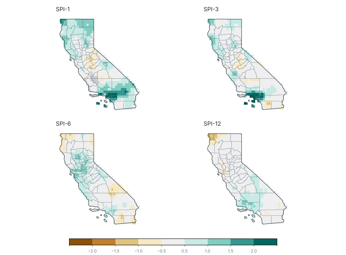
Source: NOAA NCEI
Share of the state by SPI category
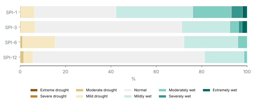
Source: NOAA NCEI
U.S. Drought Monitor, map of 29 September 2026: 23% of the state in drought (D1–D4), 0% in severe drought or worse (D2–D4) and 0% in extreme or exceptional drought (D3–D4); 72% was abnormally dry or in drought (D0–D4).
On the map of 25 August 2026, 14% of the state was in drought: a change of +9 points over the period.
SPI-3 (Jul–Sep 2026): statewide mean +0.29; 0% of the state in drought (SPI ≤ −1.0) and 0% in severe or extreme drought.
No county averaged an SPI-3 below −1.0.
SPI-1 (September 2026): 0% of the state in drought.
SPI-6 (Apr–Sep 2026): 1% of the state in drought.
SPI-12 (Oct 2025–Sep 2026): 1% of the state in drought.
7 Severe weather and notable events
No tropical cyclone came within 300 km of the state.
9 Outlook
Outlook for October 2026: most likely tercile
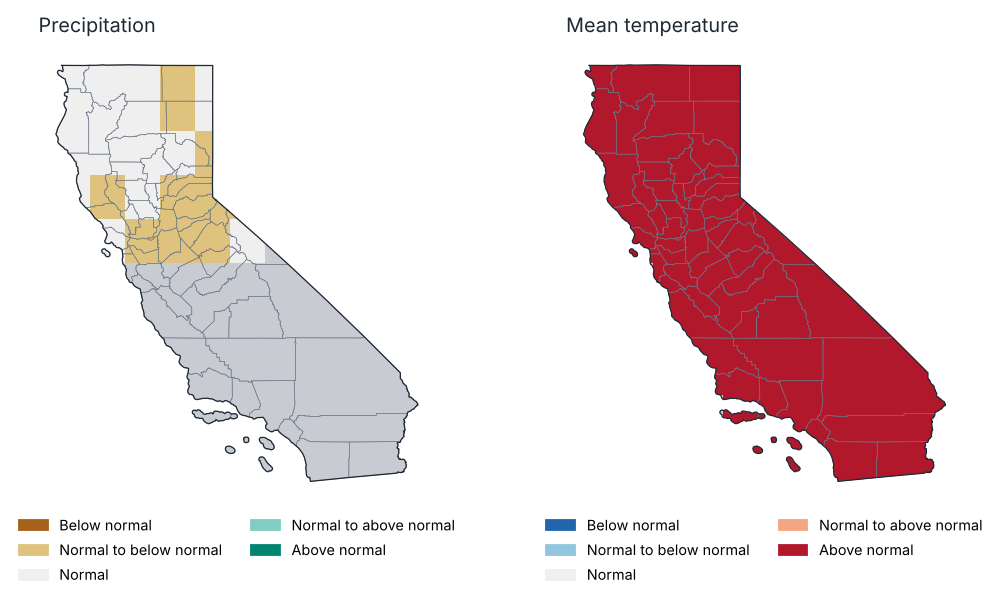
Source: NOAA CPC
Outlook for Oct–Dec 2026: most likely tercile
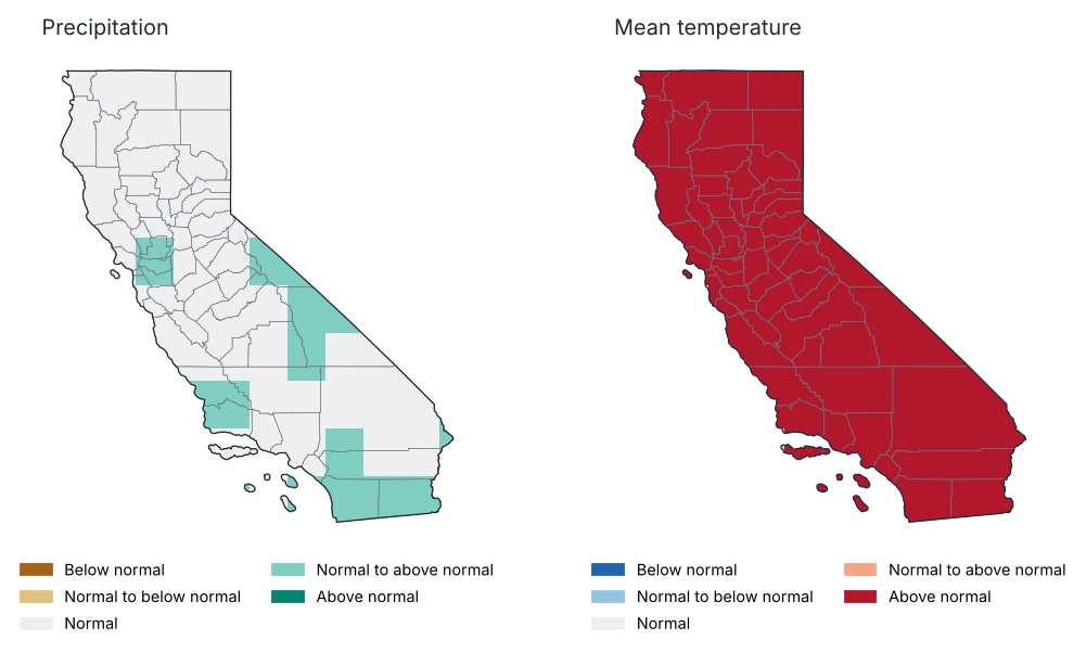
Source: NOAA CPC
Probability of each tercile by region, Oct–Dec 2026 (%)
| Region | Precipitation: below | Precipitation: normal | Precipitation: above | Temp.: below | Temp.: normal | Temp.: above |
|---|---|---|---|---|---|---|
| North Coast Drainage | 31.0 | 36.0 | 33.0 | 9.0 | 22.0 | 69.0 |
| Sacramento Drainage | 32.0 | 34.0 | 33.0 | 6.0 | 25.0 | 69.0 |
| Northeast Interior Basins | 31.0 | 33.0 | 36.0 | 6.0 | 24.0 | 70.0 |
| Central Coast Drainage | 26.0 | 36.0 | 38.0 | 9.0 | 23.0 | 67.0 |
| San Joaquin Drainage | 28.0 | 35.0 | 37.0 | 5.0 | 27.0 | 68.0 |
| South Coast Drainage | 27.0 | 34.0 | 39.0 | 6.0 | 24.0 | 70.0 |
| Southeast Desert Basin | 29.0 | 33.0 | 38.0 | 7.0 | 29.0 | 64.0 |
Source: NOAA CPC
ENSO outlook: probability of each phase (%)
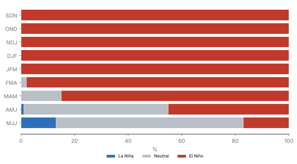
Source: NOAA CPC
Probabilistic outlook from the North American Multi-Model Ensemble (NMME), initialised in October 2026, relative to 1991–2020 terciles. It is not an official forecast: consult the National Weather Service and NOAA's Climate Prediction Center.
Precipitation, October 2026: above normal is favoured over 0% of the state and below normal over 41%.
Mean temperature, October 2026: above normal is favoured over 100% of the state and below normal over 0%.
Precipitation, Oct–Dec 2026: above normal is favoured over 22% of the state and below normal over 0%.
Mean temperature, Oct–Dec 2026: above normal is favoured over 100% of the state and below normal over 0%.
Probability of El Niño in the official ENSO outlook: SON 100%, OND 100%, NDJ 100% and DJF 100%.
10 Annexes
Report climate regions
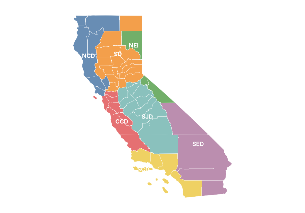
Monthly precipitation by county (mm)
| County | Jan | Feb | Mar | Apr | May | Jun | Jul | Aug | Sep |
|---|---|---|---|---|---|---|---|---|---|
| Alameda | 68.0 | 92.9 | 1.7 | 82.5 | 11.8 | 0.3 | 0.0 | 0.0 | 1.4 |
| Alpine | 86.6 | 146.3 | 22.4 | 115.4 | 40.6 | 1.1 | 18.1 | 16.7 | 4.2 |
| Amador | 117.4 | 177.9 | 8.2 | 174.3 | 28.7 | 0.7 | 1.3 | 1.8 | 2.5 |
| Butte | 164.6 | 206.2 | 3.8 | 197.3 | 32.6 | 1.2 | 0.0 | 0.0 | 10.6 |
| Calaveras | 112.6 | 168.8 | 4.7 | 147.7 | 22.7 | 0.1 | 0.4 | 1.2 | 0.9 |
| Colusa | 84.7 | 133.4 | 0.5 | 99.5 | 12.6 | 0.0 | 0.2 | 0.3 | 1.9 |
| Contra Costa | 57.6 | 81.8 | 1.8 | 67.8 | 10.1 | 0.1 | 0.0 | 0.0 | 2.0 |
| Del Norte | 138.6 | 302.2 | 38.5 | 103.8 | 12.4 | 15.1 | 0.1 | 0.2 | 94.6 |
| El Dorado | 139.5 | 200.6 | 17.8 | 186.4 | 43.0 | 1.0 | 7.2 | 3.4 | 6.0 |
| Fresno | 66.6 | 101.9 | 0.2 | 53.5 | 12.0 | 0.1 | 1.3 | 3.6 | 4.6 |
| Glenn | 108.7 | 177.3 | 0.2 | 111.1 | 27.5 | 0.1 | 0.5 | 0.1 | 2.8 |
| Humboldt | 151.9 | 285.3 | 13.7 | 107.7 | 14.9 | 13.9 | 0.6 | 1.6 | 28.3 |
| Imperial | 5.2 | 1.0 | 0.2 | 0.0 | 0.1 | 0.1 | 0.0 | 0.1 | 6.4 |
| Inyo | 19.9 | 25.0 | 0.0 | 8.2 | 6.2 | 0.1 | 0.6 | 4.9 | 4.0 |
| Kern | 36.3 | 40.3 | 0.3 | 16.5 | 2.6 | 0.0 | 0.0 | 0.2 | 1.8 |
| Kings | 28.8 | 35.4 | 0.0 | 15.0 | 1.2 | 0.0 | 0.1 | 0.0 | 0.0 |
| Lake | 154.7 | 207.5 | 1.0 | 133.7 | 22.2 | 0.2 | 1.4 | 0.7 | 6.1 |
| Lassen | 41.3 | 98.2 | 7.1 | 60.0 | 29.8 | 5.7 | 1.1 | 1.0 | 17.9 |
| Los Angeles | 65.9 | 92.4 | 1.7 | 19.3 | 2.3 | 0.0 | 0.0 | 0.0 | 18.4 |
| Madera | 69.6 | 96.6 | 0.2 | 88.9 | 10.5 | 0.3 | 1.2 | 4.0 | 2.0 |
| Marin | 120.1 | 140.2 | 0.0 | 121.1 | 19.7 | 0.4 | 0.3 | 0.1 | 5.1 |
| Mariposa | 114.3 | 131.2 | 0.9 | 128.7 | 16.4 | 0.5 | 1.0 | 3.1 | 1.6 |
| Mendocino | 153.3 | 267.7 | 5.1 | 121.9 | 19.0 | 2.0 | 1.7 | 0.6 | 16.2 |
| Merced | 35.7 | 61.8 | 0.3 | 36.5 | 5.9 | 0.0 | 0.0 | 0.0 | 0.1 |
| Modoc | 28.0 | 72.1 | 11.8 | 42.8 | 43.6 | 9.4 | 2.2 | 0.9 | 28.1 |
| Mono | 34.1 | 66.9 | 1.9 | 48.9 | 22.2 | 2.0 | 12.6 | 16.9 | 6.7 |
| Monterey | 96.5 | 151.0 | 0.0 | 58.2 | 14.3 | 0.4 | 0.7 | 1.2 | 0.3 |
| Napa | 105.8 | 124.9 | 2.9 | 95.6 | 24.1 | 0.0 | 0.3 | 0.3 | 2.9 |
| Nevada | 142.7 | 214.4 | 26.9 | 228.9 | 45.5 | 2.1 | 4.1 | 0.6 | 24.4 |
| Orange | 46.1 | 74.1 | 0.6 | 17.6 | 2.0 | 0.0 | 0.0 | 0.0 | 19.2 |
| Placer | 130.9 | 206.1 | 27.4 | 199.0 | 46.2 | 2.6 | 4.2 | 1.9 | 16.1 |
| Plumas | 128.0 | 169.5 | 2.4 | 152.9 | 33.0 | 2.5 | 1.0 | 0.2 | 20.4 |
| Riverside | 26.8 | 23.1 | 0.1 | 5.6 | 1.3 | 0.1 | 0.1 | 1.2 | 14.9 |
| Sacramento | 69.1 | 90.3 | 3.9 | 104.4 | 18.0 | 0.0 | 0.0 | 0.1 | 0.5 |
| San Benito | 59.7 | 114.3 | 0.0 | 53.9 | 12.7 | 0.1 | 0.8 | 1.2 | 0.5 |
| San Bernardino | 19.2 | 19.0 | 0.3 | 4.0 | 0.5 | 0.3 | 0.2 | 3.0 | 20.0 |
| San Diego | 72.0 | 68.5 | 0.1 | 11.3 | 9.2 | 0.6 | 0.1 | 1.1 | 2.4 |
| San Francisco | — | — | — | — | — | — | — | — | — |
| San Joaquin | 51.3 | 87.0 | 2.9 | 77.2 | 9.0 | 0.0 | 0.0 | 0.9 | 0.1 |
| San Luis Obispo | 66.3 | 114.1 | 0.0 | 40.8 | 9.4 | 0.2 | 0.5 | 0.4 | 0.0 |
| San Mateo | 108.7 | 127.6 | 0.6 | 117.9 | 12.4 | 1.0 | 0.3 | 0.7 | 1.5 |
| Santa Barbara | 87.7 | 109.0 | 0.7 | 25.5 | 2.2 | 0.0 | 0.0 | 0.4 | 0.5 |
| Santa Clara | 81.5 | 103.5 | 0.6 | 83.5 | 11.1 | 0.4 | 0.2 | 0.1 | 1.1 |
| Santa Cruz | 134.6 | 158.0 | 0.8 | 98.8 | 14.0 | 0.9 | 0.9 | 0.2 | 1.3 |
| Shasta | 128.9 | 187.0 | 6.0 | 136.6 | 39.1 | 3.9 | 0.0 | 0.1 | 19.2 |
| Sierra | 113.9 | 164.6 | 15.7 | 154.4 | 39.5 | 2.8 | 10.1 | 0.8 | 20.6 |
| Siskiyou | 65.1 | 154.8 | 13.7 | 79.5 | 47.2 | 4.4 | 0.1 | 0.2 | 28.9 |
| Solano | 73.2 | 76.1 | 1.5 | 74.8 | 15.7 | 0.0 | 0.1 | 0.0 | 1.3 |
| Sonoma | 164.9 | 177.5 | 1.0 | 121.3 | 19.6 | 1.0 | 0.2 | 0.2 | 7.1 |
| Stanislaus | 51.4 | 78.3 | 3.3 | 47.4 | 7.4 | 0.0 | 0.0 | 0.4 | 0.1 |
| Sutter | 58.7 | 89.5 | 4.6 | 71.9 | 18.8 | 0.0 | 0.0 | 0.0 | 1.2 |
| Tehama | 121.1 | 210.5 | 3.6 | 146.4 | 31.0 | 2.0 | 0.1 | 0.0 | 9.6 |
| Trinity | 154.8 | 261.4 | 7.7 | 156.4 | 36.3 | 5.0 | 0.5 | 0.5 | 18.3 |
| Tulare | 85.9 | 102.1 | 0.1 | 54.8 | 7.1 | 0.0 | 0.6 | 5.2 | 1.2 |
| Tuolumne | 124.5 | 157.8 | 8.3 | 167.1 | 28.5 | 2.4 | 4.3 | 6.8 | 2.3 |
| Ventura | 84.7 | 113.7 | 5.7 | 21.4 | 1.7 | 0.1 | 0.1 | 0.0 | 8.2 |
| Yolo | 76.6 | 75.0 | 2.4 | 74.6 | 20.4 | 0.0 | 0.2 | 0.1 | 0.6 |
| Yuba | 109.0 | 159.1 | 11.5 | 152.4 | 32.4 | 1.0 | 0.0 | 0.0 | 11.0 |
Source: NOAA NCEI
Monthly maximum temperature by region (°C)
| Region | Jan | Feb | Mar | Apr | May | Jun | Jul | Aug | Sep |
|---|---|---|---|---|---|---|---|---|---|
| North Coast Drainage | 12.0 | 12.1 | 19.5 | 16.3 | 21.4 | 25.3 | 28.5 | 29.3 | 23.7 |
| Sacramento Drainage | 13.1 | 13.2 | 21.8 | 17.5 | 23.7 | 29.1 | 32.0 | 32.8 | 26.2 |
| Northeast Interior Basins | 8.2 | 8.2 | 16.8 | 12.9 | 19.4 | 25.4 | 28.9 | 29.5 | 22.2 |
| Central Coast Drainage | 17.5 | 18.0 | 24.8 | 20.5 | 23.6 | 27.0 | 30.0 | 30.3 | 27.5 |
| San Joaquin Drainage | 14.0 | 15.8 | 23.7 | 19.9 | 25.0 | 30.5 | 33.2 | 34.3 | 28.5 |
| South Coast Drainage | 19.1 | 20.1 | 25.7 | 21.3 | 23.2 | 26.8 | 30.8 | 32.3 | 28.8 |
| Southeast Desert Basin | 17.2 | 20.4 | 28.8 | 25.2 | 30.3 | 36.4 | 38.9 | 39.5 | 33.4 |
Source: NOAA NCEI
Monthly mean temperature by region (°C)
| Region | Jan | Feb | Mar | Apr | May | Jun | Jul | Aug | Sep |
|---|---|---|---|---|---|---|---|---|---|
| North Coast Drainage | 7.3 | 7.6 | 12.3 | 10.2 | 14.4 | 17.7 | 20.4 | 21.1 | 16.5 |
| Sacramento Drainage | 7.4 | 7.7 | 14.0 | 10.9 | 16.2 | 20.6 | 23.2 | 23.7 | 17.9 |
| Northeast Interior Basins | 1.6 | 2.1 | 8.6 | 5.7 | 11.3 | 16.5 | 19.8 | 20.1 | 13.6 |
| Central Coast Drainage | 11.4 | 12.1 | 16.9 | 13.9 | 16.4 | 19.4 | 22.0 | 22.5 | 19.7 |
| San Joaquin Drainage | 8.3 | 9.8 | 16.0 | 12.9 | 17.5 | 22.3 | 25.0 | 26.0 | 20.5 |
| South Coast Drainage | 13.2 | 13.9 | 18.3 | 15.0 | 17.0 | 20.3 | 23.9 | 25.4 | 22.1 |
| Southeast Desert Basin | 11.3 | 13.7 | 20.9 | 18.0 | 22.6 | 28.5 | 31.7 | 32.4 | 26.5 |
Source: NOAA NCEI
Monthly minimum temperature by region (°C)
| Region | Jan | Feb | Mar | Apr | May | Jun | Jul | Aug | Sep |
|---|---|---|---|---|---|---|---|---|---|
| North Coast Drainage | 2.6 | 3.1 | 5.1 | 4.0 | 7.4 | 10.1 | 12.3 | 13.0 | 9.3 |
| Sacramento Drainage | 1.7 | 2.3 | 6.1 | 4.3 | 8.6 | 12.1 | 14.4 | 14.6 | 9.7 |
| Northeast Interior Basins | −5.0 | −4.1 | 0.5 | −1.6 | 3.2 | 7.6 | 10.7 | 10.8 | 5.0 |
| Central Coast Drainage | 5.3 | 6.1 | 9.0 | 7.3 | 9.3 | 11.8 | 14.0 | 14.7 | 12.0 |
| San Joaquin Drainage | 2.7 | 3.7 | 8.3 | 6.0 | 9.9 | 14.2 | 16.8 | 17.8 | 12.5 |
| South Coast Drainage | 7.4 | 7.7 | 10.9 | 8.7 | 10.7 | 13.9 | 17.0 | 18.5 | 15.4 |
| Southeast Desert Basin | 5.4 | 7.0 | 12.9 | 10.7 | 14.8 | 20.7 | 24.5 | 25.3 | 19.7 |
Source: NOAA NCEI
Stations used
| Id | Name | County | Latitude | Longitude | Altitude (m) | Days with data (Tmax) (%) |
|---|---|---|---|---|---|---|
| USC00040029 | Adin Rs | Modoc | 41.2 | −120.9 | 1280.8 | 0.0 |
| USC00040162 | Alturas 9 ENE | Modoc | 41.5 | −120.4 | 1617.6 | 0.0 |
| USC00040212 | Angwin Pacific Union College | Napa | 38.6 | −122.4 | 522.7 | 100.0 |
| USC00040332 | Arvin | Kern | 35.2 | −118.8 | 137.2 | 73.0 |
| USC00040343 | Ash Mtn | Tulare | 36.5 | −118.8 | 520.6 | 50.0 |
| USC00040444 | Bakersfield 5 NW | Kern | 35.4 | −119.1 | 143.3 | 93.0 |
| USC00040521 | Barstow | San Bernardino | 34.9 | −117.0 | 676.7 | 100.0 |
| USC00040673 | Ben Lomond #4 | Santa Cruz | 37.1 | −122.1 | 132.6 | 70.0 |
| USC00040741 | Big Bear Lake | San Bernardino | 34.2 | −116.9 | 2058.3 | 0.0 |
| USC00040790 | Big Sur Stn | Monterey | 36.2 | −121.8 | 61.0 | 100.0 |
| USC00040820 | Aspendell | Inyo | 37.2 | −118.6 | 2581.7 | 100.0 |
| USC00040823 | Bishop | Inyo | 37.4 | −118.4 | 1251.5 | 0.0 |
| USC00040931 | Boca | Nevada | 39.4 | −120.1 | 1699.3 | 47.0 |
| USC00040943 | Bodie California St Historic P | Mono | 38.2 | −119.0 | 2551.2 | 0.0 |
| USC00040983 | Borrego Desert Park | San Diego | 33.3 | −116.4 | 246.9 | 73.0 |
| USC00041018 | Bowman Dam | Nevada | 39.5 | −120.7 | 1641.3 | 0.0 |
| USC00041159 | Bucks Creek | Plumas | 39.9 | −121.3 | 576.4 | 0.0 |
| USC00041194 | Burbank Valley Pump Plt | Los Angeles | 34.2 | −118.3 | 199.6 | 33.0 |
| USC00041253 | Cachuma Lake | Santa Barbara | 34.6 | −120.0 | 240.5 | 100.0 |
| USC00041277 | Calaveras Big Trees | Calaveras | 38.3 | −120.3 | 1431.0 | 0.0 |
| USC00041312 | Calistoga | Napa | 38.6 | −122.6 | 106.7 | 100.0 |
| USC00041424 | Campo | San Diego | 32.6 | −116.5 | 801.6 | 100.0 |
| USC00041428 | Camp Pardee | Calaveras | 38.2 | −120.8 | 200.6 | 0.0 |
| USC00041614 | Cedarville | Modoc | 41.5 | −120.2 | 1428.9 | 0.0 |
| USC00041715 | Chico Univ Farm | Butte | 39.7 | −121.8 | 56.4 | 0.0 |
| USC00041738 | Chiriaco Summit | Riverside | 33.7 | −115.7 | 520.0 | 100.0 |
| USC00041758 | Chula Vista | San Diego | 32.6 | −117.1 | 17.1 | 0.0 |
| USC00041806 | Clearlake 4 SE | Lake | 38.9 | −122.6 | 411.2 | 43.0 |
| USC00041838 | Cloverdale | Sonoma | 38.8 | −123.0 | 121.9 | 100.0 |
| USC00041864 | Coalinga | Fresno | 36.1 | −120.4 | 204.2 | 0.0 |
| USC00041907 | Coleman Fisheries Stn | Shasta | 40.4 | −122.1 | 128.0 | 0.0 |
| USC00041912 | Colfax | Placer | 39.1 | −120.9 | 723.3 | 0.0 |
| USC00041948 | Colusa 2 SSW | Colusa | 39.2 | −122.0 | 15.2 | 0.0 |
| USC00042012 | Corcoran Irrig Dist | Kings | 36.1 | −119.6 | 61.0 | 0.0 |
| USC00042214 | Culver City | Los Angeles | 34.0 | −118.4 | 28.0 | 90.0 |
| USC00042239 | Cuyamaca | San Diego | 33.0 | −116.6 | 1414.3 | 100.0 |
| USC00042294 | Davis 2 WSW Exp Farm | Yolo | 38.5 | −121.8 | 18.3 | 100.0 |
| USC00042319 | Death Valley Np | Inyo | 36.5 | −116.9 | −59.1 | 100.0 |
| USC00042500 | Downieville | Sierra | 39.6 | −120.8 | 888.5 | 100.0 |
| USC00042574 | Dunsmuir Trtmt Pl | Shasta | 41.2 | −122.3 | 661.1 | 70.0 |
| USC00042598 | Eagle Mtn | Riverside | 33.8 | −115.5 | 296.6 | 0.0 |
| USC00042706 | El Cajon | San Diego | 32.8 | −116.9 | 150.9 | 100.0 |
| USC00042713 | El Centro 2 SSW | Imperial | 32.8 | −115.6 | −9.1 | 73.0 |
| USC00042863 | Escondido #2 | San Diego | 33.1 | −117.1 | 182.9 | 0.0 |
| USC00042934 | Fairfield | Solano | 38.3 | −122.1 | 12.2 | 0.0 |
| USC00042941 | Fairmont | Los Angeles | 34.7 | −118.4 | 932.7 | 0.0 |
| USC00043038 | Fiddletown Dexter Rch | Amador | 38.5 | −120.7 | 661.4 | 0.0 |
| USC00043083 | Five Points 5 SSW | Fresno | 36.4 | −120.2 | 86.9 | 0.0 |
| USC00043157 | Ft Bidwell | Modoc | 41.9 | −120.2 | 1444.4 | 0.0 |
| USC00043161 | Ft Bragg 5 N | Mendocino | 39.5 | −123.8 | 37.5 | 100.0 |
| USC00043182 | Ft Jones Rs | Siskiyou | 41.6 | −122.8 | 831.8 | 93.0 |
| USC00043191 | Ft Ross | Sonoma | 38.5 | −123.2 | 34.1 | 0.0 |
| USC00043244 | Fremont | Alameda | 37.5 | −122.0 | 11.6 | 97.0 |
| USC00043256 | Fresno 5 NE | Fresno | 36.8 | −119.7 | 103.0 | 77.0 |
| USC00043261 | Friant Government Camp | Fresno | 37.0 | −119.7 | 131.1 | 97.0 |
| USC00043357 | Gasquet Rs | Del Norte | 41.8 | −124.0 | 118.0 | 0.0 |
| USC00043402 | Gibraltar Dam #2 | Santa Barbara | 34.5 | −119.7 | 474.9 | 0.0 |
| USC00043463 | Glennville | Kern | 35.7 | −118.7 | 957.1 | 90.0 |
| USC00043551 | Grant Grove | Tulare | 36.7 | −119.0 | 2005.6 | 100.0 |
| USC00043573 | Grass Valley #2 | Nevada | 39.2 | −121.1 | 731.5 | 100.0 |
| USC00043578 | Graton | Sonoma | 38.4 | −122.9 | 61.0 | 100.0 |
| USC00043714 | Half Moon Bay | San Mateo | 37.5 | −122.4 | 8.2 | 100.0 |
| USC00043747 | Hanford 1 S | Kings | 36.3 | −119.6 | 72.2 | 87.0 |
| USC00043761 | Happy Camp Rs | Siskiyou | 41.8 | −123.4 | 348.1 | 0.0 |
| USC00043855 | Hayfield Pumping Plt | Riverside | 33.7 | −115.6 | 417.6 | 87.0 |
| USC00043875 | Healdsburg | Sonoma | 38.6 | −122.9 | 53.9 | 27.0 |
| USC00043882 | Hearst Castle | San Luis Obispo | 35.7 | −121.2 | 465.1 | 97.0 |
| USC00043914 | Henshaw Dam | San Diego | 33.2 | −116.8 | 823.0 | 100.0 |
| USC00043939 | Hetch Hetchy | Tuolumne | 38.0 | −119.8 | 1179.6 | 0.0 |
| USC00044025 | Hollister 2 | San Benito | 36.8 | −121.4 | 83.8 | 0.0 |
| USC00044211 | Idyllwild Fire Dept | Riverside | 33.8 | −116.7 | 1639.8 | 0.0 |
| USC00044297 | Iron Mtn | San Bernardino | 34.1 | −115.1 | 281.0 | 50.0 |
| USC00044374 | Jess Valley | Modoc | 41.3 | −120.3 | 1621.2 | 0.0 |
| USC00044405 | Joshua Tree | San Bernardino | 34.1 | −116.3 | 781.2 | 100.0 |
| USC00044422 | Juncal Dam | Santa Barbara | 34.5 | −119.5 | 688.8 | 0.0 |
| USC00044484 | Kelsey 1 N | El Dorado | 38.8 | −120.8 | 609.6 | 0.0 |
| USC00044500 | Kentfield | Marin | 38.0 | −122.5 | 44.2 | 100.0 |
| USC00044534 | Kettleman City | Kings | 36.0 | −120.0 | 73.2 | 53.0 |
| USC00044555 | King City | Monterey | 36.2 | −121.1 | 97.5 | 100.0 |
| USC00044710 | Lakeside 2 E | San Diego | 32.9 | −116.9 | 210.3 | 0.0 |
| USC00044712 | Lake Solano | Solano | 38.5 | −122.0 | 57.0 | 100.0 |
| USC00044881 | Lee Vining | Mono | 38.0 | −119.1 | 2071.7 | 100.0 |
| USC00044890 | Lemon Cove | Tulare | 36.4 | −119.0 | 156.4 | 100.0 |
| USC00044957 | Lindsay | Tulare | 36.2 | −119.1 | 132.6 | 87.0 |
| USC00044997 | Livermore | Alameda | 37.7 | −121.8 | 161.2 | 100.0 |
| USC00045091 | Long Valley 2 | Riverside | 33.8 | −116.6 | 2554.2 | 0.0 |
| USC00045100 | Loraine 5 NNE | Kern | 35.4 | −118.4 | 1290.8 | 90.0 |
| USC00045118 | Los Banos | Merced | 37.1 | −120.9 | 36.6 | 97.0 |
| USC00045360 | Markley Cove | Napa | 38.5 | −122.1 | 146.3 | 100.0 |
| USC00045449 | Mccloud | Siskiyou | 41.3 | −122.1 | 985.4 | 77.0 |
| USC00045598 | Middletown | Lake | 38.7 | −122.6 | 341.7 | 0.0 |
| USC00045739 | Modesto Irrig Dist | Mariposa | 37.6 | −120.0 | 26.8 | 0.0 |
| USC00045795 | Monterey | Monterey | 36.6 | −121.9 | 37.2 | 100.0 |
| USC00045933 | Mt Hamilton | Santa Clara | 37.3 | −121.6 | 1286.3 | 100.0 |
| USC00045983 | Mt Shasta | Siskiyou | 41.3 | −122.3 | 1101.2 | 0.0 |
| USC00046027 | Muir Woods | Marin | 37.9 | −122.6 | 67.1 | 0.0 |
| USC00046074 | Napa State Hospital | Napa | 38.3 | −122.3 | 10.7 | 97.0 |
| USC00046136 | Nevada City | Nevada | 39.2 | −121.0 | 847.6 | 90.0 |
| USC00046154 | New Cuyama Fire Stn | Santa Barbara | 34.9 | −119.7 | 658.4 | 20.0 |
| USC00046168 | Newman | Merced | 37.3 | −121.0 | 27.4 | 100.0 |
| USC00046174 | New Melones Dam Hq | Tuolumne | 38.0 | −120.5 | 292.6 | 100.0 |
| USC00046175 | Newport Beach Harbor | Orange | 33.6 | −117.9 | 3.0 | 0.0 |
| USC00046252 | N Fk Rs | Madera | 37.2 | −119.5 | 806.2 | 67.0 |
| USC00046336 | Oakland Museum | Alameda | 37.8 | −122.3 | 9.1 | 100.0 |
| USC00046399 | Ojai | Ventura | 34.4 | −119.2 | 227.1 | 23.0 |
| USC00046508 | Orleans | Humboldt | 41.3 | −123.5 | 122.8 | 47.0 |
| USC00046572 | Oxnard Wfo | Ventura | 34.2 | −119.1 | 15.8 | 0.0 |
| USC00046624 | Palmdale | Los Angeles | 34.6 | −118.1 | 796.1 | 0.0 |
| USC00046657 | Palomar Mtn Obsy | San Diego | 33.4 | −116.8 | 1691.6 | 33.0 |
| USC00046699 | Parker Rsvr | San Bernardino | 34.3 | −114.2 | 224.9 | 0.0 |
| USC00046719 | Pasadena | Los Angeles | 34.1 | −118.1 | 263.3 | 0.0 |
| USC00046730 | Paso Robles | San Luis Obispo | 35.6 | −120.7 | 222.5 | 57.0 |
| USC00046773 | Pearblossom | Los Angeles | 34.5 | −117.9 | 945.2 | 0.0 |
| USC00046826 | Petaluma AP | Sonoma | 38.3 | −122.6 | 6.1 | 47.0 |
| USC00046926 | Pinnacles Np | San Benito | 36.5 | −121.2 | 398.4 | 100.0 |
| USC00046940 | Piru 2 ESE | Ventura | 34.4 | −118.8 | 217.0 | 0.0 |
| USC00046961 | Placerville 3 ENE | El Dorado | 38.8 | −120.7 | 810.2 | 27.0 |
| USC00047085 | Portola | Plumas | 39.8 | −120.5 | 1478.3 | 0.0 |
| USC00047109 | Potter Valley Powerhouse | Mendocino | 39.4 | −123.1 | 310.3 | 100.0 |
| USC00047195 | Quincy | Plumas | 39.9 | −120.9 | 1042.4 | 100.0 |
| USC00047306 | Redlands | San Bernardino | 34.0 | −117.2 | 429.8 | 0.0 |
| USC00047326 | Redondo Beach | Los Angeles | 33.8 | −118.4 | 43.3 | 30.0 |
| USC00047339 | Redwood City | San Mateo | 37.5 | −122.2 | 9.4 | 100.0 |
| USC00047414 | Richmond | Contra Costa | 37.9 | −122.4 | 6.1 | 73.0 |
| USC00047702 | San Andreas 2 | Calaveras | 38.2 | −120.7 | 335.3 | 0.0 |
| USC00047767 | San Francisco Oceanside | San Francisco | 37.7 | −122.5 | 2.4 | 100.0 |
| USC00047776 | San Gabriel Canyon Ph | Los Angeles | 34.2 | −117.9 | 226.8 | 0.0 |
| USC00047785 | San Gabriel Fire Dept | Los Angeles | 34.1 | −118.1 | 110.6 | 0.0 |
| USC00047813 | San Jacinto | Riverside | 33.8 | −117.0 | 464.8 | 100.0 |
| USC00047821 | San Jose | Santa Clara | 37.4 | −121.9 | 14.9 | 100.0 |
| USC00047851 | San Luis Obispo Poly | San Luis Obispo | 35.3 | −120.7 | 93.9 | 30.0 |
| USC00047880 | San Rafael-Civic Ctr | Marin | 38.0 | −122.5 | 36.6 | 100.0 |
| USC00047902 | Santa Barbara | Santa Barbara | 34.4 | −119.7 | 4.9 | 100.0 |
| USC00047933 | Santa Margarita Boost | San Luis Obispo | 35.4 | −120.6 | 349.9 | 0.0 |
| USC00047965 | Santa Rosa | Sonoma | 38.5 | −122.7 | 50.6 | 97.0 |
| USC00048014 | Saugus Pwr Plt 1 | Los Angeles | 34.6 | −118.5 | 658.7 | 0.0 |
| USC00048122 | Shafter 6E | Kern | 35.5 | −119.1 | 123.1 | 0.0 |
| USC00048135 | Shasta Dam | Shasta | 40.7 | −122.4 | 327.7 | 40.0 |
| USC00048218 | Sierraville Rs | Sierra | 39.6 | −120.4 | 1516.4 | 43.0 |
| USC00048273 | Skyline Ridge Preserve | San Mateo | 37.3 | −122.2 | 691.9 | 0.0 |
| USC00048351 | Sonoma | Sonoma | 38.3 | −122.5 | 29.6 | 100.0 |
| USC00048353 | Sonora | Tuolumne | 38.0 | −120.4 | 510.5 | 100.0 |
| USC00048380 | So Entrance Yosemite Np | Mariposa | 37.5 | −119.6 | 1538.3 | 23.0 |
| USC00048407 | S Lake Fs | Kern | 35.6 | −118.4 | 808.9 | 97.0 |
| USC00048587 | Stony Gorge Rsvr | Glenn | 39.6 | −122.5 | 243.8 | 0.0 |
| USC00048606 | Strawberry Valley 2 | Butte | 39.5 | −121.2 | 1130.8 | 97.0 |
| USC00048702 | Susanville 2SW | Lassen | 40.4 | −120.7 | 1283.8 | 60.0 |
| USC00048713 | Sutter Hill Cdf | Amador | 38.4 | −120.8 | 483.4 | 53.0 |
| USC00048758 | Tahoe City | Placer | 39.2 | −120.1 | 1898.9 | 100.0 |
| USC00048760 | Tahoma | El Dorado | 39.1 | −120.1 | 1924.8 | 87.0 |
| USC00048839 | Tejon Rancho | Kern | 35.0 | −118.7 | 434.3 | 20.0 |
| USC00048999 | Tracy Carbona | San Joaquin | 37.7 | −121.3 | 41.1 | 0.0 |
| USC00049001 | Tracy Pumping Plt | Alameda | 37.8 | −121.6 | 18.6 | 93.0 |
| USC00049035 | Trona | San Bernardino | 35.8 | −117.4 | 516.6 | 97.0 |
| USC00049053 | Tulelake | Siskiyou | 42.0 | −121.5 | 1230.8 | 77.0 |
| USC00049063 | Tuolumne Meadows Rs | Tuolumne | 37.9 | −119.3 | 2649.9 | 77.0 |
| USC00049099 | Twentynine Palms | San Bernardino | 34.1 | −116.0 | 602.0 | 0.0 |
| USC00049111 | Twitchell Dam | Santa Barbara | 35.0 | −120.3 | 177.4 | 50.0 |
| USC00049152 | U C L A | Los Angeles | 34.1 | −118.4 | 131.1 | 100.0 |
| USC00049185 | Upper San Leandro Filters | Alameda | 37.8 | −122.2 | 120.1 | 0.0 |
| USC00049219 | Vallejo | Solano | 38.1 | −122.2 | 103.9 | 100.0 |
| USC00049226 | Valley Ctr 1N | San Diego | 33.2 | −117.0 | 393.2 | 0.0 |
| USC00049298 | Verdi 2W | Sierra | 39.5 | −120.0 | 1654.8 | 63.0 |
| USC00049367 | Visalia | Tulare | 36.3 | −119.3 | 92.4 | 97.0 |
| USC00049378 | Vista | San Diego | 33.2 | −117.2 | 131.1 | 0.0 |
| USC00049390 | Volta Ph | Shasta | 40.5 | −121.9 | 676.7 | 0.0 |
| USC00049452 | Wasco | Kern | 35.6 | −119.4 | 88.7 | 43.0 |
| USC00049473 | Watsonville Wtr Wks | Santa Cruz | 36.9 | −121.8 | 29.0 | 100.0 |
| USC00049582 | W Pt | Calaveras | 38.4 | −120.5 | 845.8 | 0.0 |
| USC00049621 | Whiskeytown Rsvr | Shasta | 40.6 | −122.5 | 394.7 | 20.0 |
| USC00049742 | Winters | Yolo | 38.5 | −122.0 | 41.1 | 90.0 |
| USC00049785 | Woodland Hills Pierce College | Los Angeles | 34.2 | −118.6 | 240.8 | 0.0 |
| USC00049855 | Yosemite Park Hq | Mariposa | 37.8 | −119.6 | 1224.7 | 0.0 |
| USC00049866 | Yreka | Siskiyou | 41.7 | −122.6 | 826.6 | 93.0 |
| USC00049884 | Yucca Mesa | San Bernardino | 34.2 | −116.4 | 1050.0 | 100.0 |
| USW00003102 | Ontario Intl AP | San Bernardino | 34.1 | −117.6 | 281.6 | 100.0 |
| USW00003104 | Desert Resorts Rgnl AP | Riverside | 33.6 | −116.2 | −36.0 | 100.0 |
| USW00003122 | Torrance AP | Los Angeles | 33.8 | −118.3 | 27.4 | 100.0 |
| USW00003131 | San Diego Montgomery Fld | San Diego | 32.8 | −117.1 | 127.4 | 100.0 |
| USW00003144 | Imperial Co AP | Imperial | 32.8 | −115.6 | −16.8 | 100.0 |
| USW00003154 | Camp Pendleton Mcas | San Diego | 33.3 | −117.4 | 21.3 | 100.0 |
| USW00003159 | Lancaster | Los Angeles | 34.7 | −118.2 | 712.6 | 100.0 |
| USW00003166 | Fullerton Muni AP | Orange | 33.9 | −118.0 | 26.2 | 100.0 |
| USW00003167 | Hawthorne Muni AP | Los Angeles | 33.9 | −118.3 | 16.8 | 100.0 |
| USW00003171 | Riverside Muni AP | Riverside | 34.0 | −117.4 | 257.6 | 100.0 |
| USW00003177 | Carlsbad Mcclellan Palomar AP | San Diego | 33.1 | −117.3 | 95.4 | 93.0 |
| USW00003178 | San Diego Brown Fld | San Diego | 32.6 | −117.0 | 158.8 | 100.0 |
| USW00003179 | Chino AP | San Bernardino | 34.0 | −117.6 | 193.9 | 97.0 |
| USW00004222 | Redding 12 WNW | Shasta | 40.7 | −122.6 | 432.2 | 100.0 |
| USW00023110 | Lemoore Reeves Nas | Kings | 36.3 | −120.0 | 70.7 | 100.0 |
| USW00023114 | Edwards Afb | Kern | 34.9 | −117.9 | 705.9 | 93.0 |
| USW00023119 | March Afb | Riverside | 33.9 | −117.2 | 468.2 | 100.0 |
| USW00023122 | Norton Afb | San Bernardino | 34.1 | −117.2 | 338.9 | 100.0 |
| USW00023129 | Long Beach Daugherty AP | Los Angeles | 33.8 | −118.1 | 10.4 | 100.0 |
| USW00023130 | Van Nuys AP | Los Angeles | 34.2 | −118.5 | 239.3 | 100.0 |
| USW00023131 | Victorville So Ca AP | San Bernardino | 34.6 | −117.4 | 869.0 | 93.0 |
| USW00023136 | Camarillo AP | Ventura | 34.2 | −119.1 | 21.6 | 97.0 |
| USW00023152 | Burbank Glendale Pasadena AP | Los Angeles | 34.2 | −118.4 | 222.8 | 100.0 |
| USW00023155 | Bakersfield AP | Kern | 35.4 | −119.1 | 149.4 | 100.0 |
| USW00023157 | Bishop AP | Inyo | 37.4 | −118.4 | 1252.7 | 100.0 |
| USW00023158 | Blythe Asos | Riverside | 33.6 | −114.7 | 120.4 | 93.0 |
| USW00023161 | Barstow-Daggett AP | San Bernardino | 34.9 | −116.8 | 584.9 | 97.0 |
| USW00023174 | Los Angeles Intl AP | Los Angeles | 33.9 | −118.4 | 29.6 | 97.0 |
| USW00023179 | Needles AP | San Bernardino | 34.8 | −114.6 | 270.7 | 100.0 |
| USW00023182 | Palmdale AP | Los Angeles | 34.6 | −118.1 | 764.7 | 100.0 |
| USW00023187 | Sandberg | Los Angeles | 34.7 | −118.7 | 1374.6 | 100.0 |
| USW00023188 | San Diego Intl AP | San Diego | 32.7 | −117.2 | 4.6 | 100.0 |
| USW00023190 | Santa Barbara Muni AP | Santa Barbara | 34.4 | −119.8 | 2.4 | 100.0 |
| USW00023191 | Avalon Catalina AP | Los Angeles | 33.4 | −118.4 | 477.0 | 100.0 |
| USW00023199 | El Centro Naf | Imperial | 32.8 | −115.7 | −14.0 | 100.0 |
| USW00023202 | Travis Afb | Solano | 38.3 | −121.9 | 18.0 | 100.0 |
| USW00023206 | Sacramento Mather Afb | Sacramento | 38.6 | −121.3 | 39.9 | 100.0 |
| USW00023208 | Sacramento Mcclellan Afb | Sacramento | 38.7 | −121.4 | 25.0 | 100.0 |
| USW00023213 | Santa Rosa Sonoma Co AP | Sonoma | 38.5 | −122.8 | 36.3 | 100.0 |
| USW00023225 | Blue Canyon Nyack AP | Placer | 39.3 | −120.7 | 1611.2 | 100.0 |
| USW00023230 | Oakland Intl AP | Alameda | 37.7 | −122.2 | 1.5 | 100.0 |
| USW00023232 | Sacramento AP Asos | Sacramento | 38.5 | −121.5 | 5.8 | 100.0 |
| USW00023233 | Salinas AP | Monterey | 36.7 | −121.6 | 22.3 | 100.0 |
| USW00023234 | San Francisco Intl AP | San Mateo | 37.6 | −122.4 | 3.0 | 100.0 |
| USW00023237 | Stockton AP | San Joaquin | 37.9 | −121.2 | 8.2 | 100.0 |
| USW00023243 | Lompoc AP | Santa Barbara | 34.7 | −120.5 | 26.8 | 0.0 |
| USW00023244 | Moffett Fed Airfield | Santa Clara | 37.4 | −122.0 | 11.9 | 100.0 |
| USW00023254 | Concord Buchanan Fld | Contra Costa | 38.0 | −122.1 | 7.0 | 100.0 |
| USW00023257 | Merced Muni AP | Merced | 37.3 | −120.5 | 46.3 | 100.0 |
| USW00023258 | Modesto AP | Stanislaus | 37.6 | −121.0 | 26.5 | 100.0 |
| USW00023259 | Monterey Peninsul AP | Monterey | 36.6 | −121.8 | 48.8 | 100.0 |
| USW00023272 | San Francisco Dwtn | San Francisco | 37.8 | −122.4 | 45.7 | 100.0 |
| USW00023273 | Santa Maria Public AP | Santa Barbara | 34.9 | −120.5 | 74.1 | 97.0 |
| USW00023275 | Ukiah Muni AP | Mendocino | 39.1 | −123.2 | 183.8 | 83.0 |
| USW00023277 | Watsonville Muni AP | Santa Cruz | 36.9 | −121.8 | 49.4 | 100.0 |
| USW00023285 | Livermore Muni AP | Alameda | 37.7 | −121.8 | 119.8 | 100.0 |
| USW00023293 | San Jose | Santa Clara | 37.4 | −121.9 | 14.9 | 100.0 |
| USW00024213 | Eureka Wfo Woodley Is | Humboldt | 40.8 | −124.2 | 6.1 | 97.0 |
| USW00024215 | Mt Shasta | Siskiyou | 41.3 | −122.3 | 1083.0 | 100.0 |
| USW00024216 | Red Bluff Muni AP | Tehama | 40.2 | −122.3 | 107.9 | 100.0 |
| USW00024257 | Redding AP | Shasta | 40.5 | −122.3 | 152.7 | 100.0 |
| USW00024259 | Montague Siskiyou AP | Siskiyou | 41.8 | −122.5 | 806.2 | 100.0 |
| USW00024283 | Arcata Eureka AP | Humboldt | 41.0 | −124.1 | 64.3 | 97.0 |
| USW00024286 | Crescent City Mcnamara AP | Del Norte | 41.8 | −124.2 | 17.1 | 0.0 |
| USW00053119 | Hanford Muni AP | Kings | 36.3 | −119.6 | 75.9 | 100.0 |
| USW00053120 | Ramona AP | San Diego | 33.0 | −116.9 | 422.1 | 100.0 |
| USW00053121 | Oceanside Muni AP | San Diego | 33.2 | −117.3 | 9.1 | 97.0 |
| USW00053139 | Stovepipe Wells 1 SW | Inyo | 36.6 | −117.1 | 25.6 | 100.0 |
| USW00053144 | Edwards Afb N Aux Airfield | Kern | 35.0 | −117.9 | 695.9 | 97.0 |
| USW00053150 | Yosemite Village 12 W | Mariposa | 37.8 | −119.8 | 2017.8 | 100.0 |
| USW00053151 | Fallbrook 5 NE | Riverside | 33.4 | −117.2 | 347.5 | 100.0 |
| USW00053152 | Santa Barbara 11 W | Santa Barbara | 34.4 | −119.9 | 5.5 | 100.0 |
| USW00053175 | Corona Municipal AP | Riverside | 33.9 | −117.6 | 162.5 | 100.0 |
| USW00093104 | China Lake Naf | Kern | 35.7 | −117.7 | 680.0 | 80.0 |
| USW00093107 | San Diego Miramar Nas | San Diego | 32.9 | −117.1 | 145.4 | 100.0 |
| USW00093110 | Oxnard Ventura Co AP | Ventura | 34.2 | −119.2 | 11.9 | 100.0 |
| USW00093111 | Pt Mugu Nf | Ventura | 34.1 | −119.1 | 3.7 | 97.0 |
| USW00093112 | N Is Nas | San Diego | 32.7 | −117.2 | 4.3 | 97.0 |
| USW00093115 | Imperial Beach Ream Fld Nas | San Diego | 32.6 | −117.1 | 7.3 | 97.0 |
| USW00093116 | San Nicolas Is | Ventura | 33.2 | −119.5 | 161.2 | 87.0 |
| USW00093121 | Twentynine Palms Mc | San Bernardino | 34.3 | −116.2 | 643.1 | 0.0 |
| USW00093134 | Los Angeles Downtown/Usc | Los Angeles | 34.0 | −118.3 | 54.6 | 100.0 |
| USW00093138 | Palm Springs Asos | Riverside | 33.8 | −116.5 | 124.7 | 100.0 |
| USW00093184 | Santa Ana John Wayne AP | Orange | 33.7 | −117.9 | 13.1 | 100.0 |
| USW00093193 | Fresno Yosemite Intl | Fresno | 36.8 | −119.7 | 101.8 | 100.0 |
| USW00093197 | Santa Monica Muni AP | Los Angeles | 34.0 | −118.4 | 53.3 | 100.0 |
| USW00093205 | Marysville AP (Asos) | Yuba | 39.1 | −121.6 | 18.9 | 100.0 |
| USW00093206 | San Luis Obispo Mcchesney Fld | San Luis Obispo | 35.2 | −120.6 | 55.8 | 100.0 |
| USW00093209 | Paso Robles Muni AP | San Luis Obispo | 35.7 | −120.6 | 249.9 | 100.0 |
| USW00093210 | Oroville Muni AP | Butte | 39.5 | −121.6 | 57.0 | 100.0 |
| USW00093214 | Vandenberg Afb | Santa Barbara | 34.7 | −120.6 | 116.1 | 97.0 |
| USW00093216 | Beale Afb | Yuba | 39.1 | −121.4 | 38.1 | 100.0 |
| USW00093225 | Sacramento Metro AP | Sacramento | 38.7 | −121.6 | 7.3 | 100.0 |
| USW00093227 | Napa Co AP | Napa | 38.2 | −122.3 | 4.9 | 100.0 |
| USW00093228 | Hayward Air Terminal | Alameda | 37.7 | −122.1 | 9.4 | 100.0 |
| USW00093230 | S Lake Tahoe AP | El Dorado | 38.9 | −120.0 | 1907.1 | 100.0 |
| USW00093241 | Vacaville/Nut Tree AP Asos | Solano | 38.4 | −122.0 | 31.7 | 100.0 |
| USW00093242 | Madera Muni AP | Madera | 37.0 | −120.1 | 76.5 | 100.0 |
| USW00093243 | Merced 23 WSW | Merced | 37.2 | −120.9 | 23.8 | 100.0 |
| USW00094299 | Alturas Muni AP | Modoc | 41.5 | −120.6 | 1335.9 | 67.0 |
Source: NOAA NCEI
11 Glossary, methodology and sources
Anomaly: difference between the observed value and its 1991–2020 normal. Percent of normal: observed total divided by the normal, times 100. Station record: most extreme daily value for the same month in all earlier years of record (at least 20 years).
Temperature: NOAA nClimGrid-Daily. Precipitation: NOAA nClimGrid-Daily. nClimGrid-Daily is the grid behind NOAA's official statewide values; it is averaged here from 1/24° to 1/8° (about 12 km). Mean temperature is (Tmax + Tmin)/2. Statewide, regional and county averages are weighted by the area of each grid cell inside each polygon. Temperature maps, frost days and annex tables are given by region; regions are NOAA NCEI climate divisions, with each county in the division of its centroid. Recent weeks use NCEI's preliminary file of the month; such reports are marked preliminary and updated when the final file is published. Normals refer to 1991-2020; ranks compare values rounded to one decimal. Stations: GHCN-Daily (NOAA NCEI) cooperative and first-order stations; values flagged by its quality control are discarded, as are daily values more than 5 robust standard deviations from the station median and variables whose monthly anomaly differs by more than 3 °C from the gridded analysis. Period means require at least 80% of days with data and station normals at least 20 complete years. This report is generated automatically and does not replace official information from the National Weather Service or the state climatologist.
| Source | Product | License | Citation |
|---|---|---|---|
| NOAA CPC | Official ENSO probabilities | Public domain (NOAA) | — |
| NOAA CPC | ONI, Niño-region SST indices (OISST v2.1), NAO and AO | Public domain (NOAA) | NOAA Climate Prediction Center climate indices. |
| NOAA NCEI / PSL | Extended Reconstructed SST v5 (ERSST v5), 2° | Public domain (NOAA) | Huang et al. (2017), J. Climate, doi:10.1175/JCLI-D-16-0836.1 |
| GDACS | Global Disaster Alert and Coordination System event list | See provider terms | — |
| NOAA NCEI | GHCN-Daily | Public domain (NOAA) | Menne et al. (2012), J. Atmos. Oceanic Technol., doi:10.1175/JTECH-D-11-00103.1 |
| NOAA NCEI | IBTrACS v04r01 tropical-cyclone best tracks | Public domain (NOAA) | Knapp et al. (2010), Bull. Amer. Meteor. Soc., doi:10.1175/2009BAMS2755.1 |
| NOAA NCEI | Pacific Decadal Oscillation index (ERSST v5) | Public domain (NOAA) | — |
| NOAA NCEI | nClimGrid-Daily, contiguous United States (1/24°, averaged here to 1/8°) | Public domain (NOAA) | Durre, I., et al. (2022). NOAA's nClimGrid-Daily Version 1. NOAA National Centers for Environmental Information. doi:10.25921/c4gt-r169 |
| NOAA CPC | North American Multi-Model Ensemble (NMME) tercile probabilities, 1° | Public domain (NOAA) | Kirtman et al. (2014), Bull. Amer. Meteor. Soc., doi:10.1175/BAMS-D-12-00050.1 |
| NOAA PSL | Real-time OLR MJO Index (ROMI) | Public domain (NOAA) | Kiladis et al. (2014), Mon. Wea. Rev., doi:10.1175/MWR-D-13-00301.1 |
| National Drought Mitigation Center, USDA, NOAA | U.S. Drought Monitor, weekly maps and area statistics | Free to use with credit (NDMC) | The U.S. Drought Monitor is jointly produced by the National Drought Mitigation Center at the University of Nebraska-Lincoln, the United States Department of Agriculture and the National Oceanic and Atmospheric Administration. Map courtesy of NDMC. |
| US Census Bureau TIGERweb | US Census Bureau, TIGERweb counties (generalised) | Public domain (US Government work) | — |
Generated by ClimaBulletin (climabulletin.org), open source. Questions and comments: [email protected].